
Riding the Rails
NEW YORK TIMES | From New York to California by Amtrak.
FIRST PUBLISHED IN THE NEW YORK TIMES, MARCH 8, 2009
SOMEWHERE on the west side of Illinois, the Amish men broke out a deck of Skip-Bo cards and I joined them as the cafe car attendant, using an iPod and a set of portable speakers, broadcast Eckhart Tolle, author of “A New Earth,” discoursing on the virtues of stillness.
“Life gets discombobulating,” the attendant said, calmly. “This helps.”
On both sides of the train window, American scenery unfolded. A dirty layer of ice and snow subdued the still cropland to the distant horizon. At the next table a woman stuck her nose in a novel; a college kid pecked at a laptop. Overlaying all this, a soundtrack: choo-k-choo-k-choo-k-choo-k-choo-k — the metronomic rhythm of an Amtrak train rolling down the line to California, a sound that called to mind an old camera reel moving frames of images along a linear track, telling a story.
The six Amish men were in their mid-20s, and they were returning home to Kalona, Iowa, after a three-week cross-country tour. They had especially liked the Creation Museum, in Petersburg, Ky., and Niagara Falls. As we rolled across white plains, they pointed out which plots grew beans and which grew corn. To my eye, the dormant land revealed few clues.
Around the train car lounged Americans traveling for work and others for family, people for whom train travel is a necessity and those for whom it’s merely quaint, first-time riders and probably even a few “foamers” — the nickname that train workers privately give the buffs who salivate over the sight of a locomotive.
I had ridden long-distance trains in India and China but never across my own country. I suppose that after two years of receiving images saturated in red, white and blue from all corners of the nation, I wanted to make my own. The fading glow of the Inauguration, I thought — a moment for national unity and new beginning, both imagined and real — would be a good light in which to meet the country again. And it was winter, after all; I didn’t feel like driving.
With every uptick in gas prices, Americans in general are thinking less about driving. With each degree of global warming, trains become even more sensible. And with each new surcharge and each new item of clothing one is required to remove to board an airplane — and with every small-town commercial airport and cabin amenity that vanishes forever — the rails beckon. Last year, Amtrak set all-time ridership records.
Traveling cross-country by train takes time, but less than I expected: within four days, one crosses the Hudson River and reaches San Francisco Bay at Emeryville, Calif. I gave myself a week, stopping in Chicago, Denver and, for variety, a remote town in Nevada that had a nice ring to its name.
THE Amtrak Cardinal rolled out of New York’s Pennsylvania Station slightly before dawn on a frigid January morning. I had booked a roomette — a cozy compartment just larger than a Japanese capsule that converts from two facing seats into bunk beds. The attendant asked if I wanted a wake-up call the next morning, pointed out the showers down the hall and said that breakfast would be served after Trenton.
The roomette’s décor — blue curtains, a (sealed) metal ashtray on the armrest — evoked the era of Pan Am. On the upholstered seats rested two hangers, two pillows and a crisp copy of The New York Times, which on that morning featured a photo of the ex-Illinois governor, Rod Blagojevich, projecting an image of false calm. Chicago, all aboard.
On a two-dimensional map, the crosshatched lines that represent railroad tracks resemble stitches binding patches of textured fabric. Essentially, these remnants of America’s rail network predate 1910, and unless you’re on it, you scarcely notice it — crossing under our freeways, passing through once-thriving rural towns that today’s highways avoid. We consider train tracks indifferently, the way we do electricity wires: as behind-the-scenes infrastructure, a ubiquitous but background feature of our landscape.
At least this is how it seemed en route to Washington, as the train rolled past unkempt backyards and graffitied factory walls, icy ball fields and the back doors of crumbling buildings. America presents itself to the streets; the tracks take in a less manicured backside. How refreshing a sight.
Our consumer society may still rely on trains to transport things, but those things are pitched to drivers in cars, not to passengers on trains. And so, as early as New Jersey, I realized something that would only feel remarkable a few days later, in the Nevada desert: it’s still possible to travel 3,585 miles across the United States without being the target of billboards, golden arches or absurdly large twine balls. The rails offer a view onto Unbranded America — the land as it was.
The Cardinal makes 31 stops in 27 hours on a southerly, U-shaped path from New York to Chicago. It’s not the most direct of Amtrak’s routes, but it charts a course through textbook American history: Baltimore; Washington; Manassas, Va.; Cincinnati.
At Philadelphia, a woman named Mary Ellen Phillips Belcher and her grown daughter Ladonna settled into the roomette across from mine. They were returning home to Kentucky after visiting a relative in suburban Pennsylvania. They usually drive; the train ride was satisfying a long-held curiosity.
Life stories and first names have a way of surfacing between strangers. Mary Ellen lived her girlhood days in Junction City, Ky., with four brothers and a single mom, along the old Louisville and Nashville Railroad tracks.
“We didn’t have money to buy cigarettes, so we’d get us a coffee can and collect the butts thrown off the train,” she said. “Mother would always leave a skillet of cornbread and brown beans outside the house for the hobos coming through. Evidently, they had passed word on to their friends that Mother was a kind lady. She’d never have enough food for us, but she’d always have something for somebody.”
“I said, ‘One of these days I’m going to ride a train to remember Mother and those hobos’ ” she told me, in way that moved me. “I guess I had to be 65 before I took that ’venture.”
Behind her, Washington’s monuments drifted slowly across the glass, and as we passed the Capitol, I imagined a bureaucrat inside considering what to do about Amtrak. As a quasi-public rail service, Amtrak stays afloat with a little more than $1 billion a year from the federal government. Last September, for the first time since 1997, Congress approved an Amtrak authorization bill that could nearly double it. The stimulus package President Obama signed in February includes $8 billion for high-speed and intercity rail projects, and one would think that so long as “Amtrak Joe” Biden holds high office, trains will continue to get some love.
After Charlottesville, Va., I planted myself in the lounge car, which divides the coach and sleeper cars and serves the social function of the train’s town square or neighborhood pub — an egalitarian place for conversation and chips.
“D’ya see that doe?” a man from Virginia asked me, pointing outside. “Still as can be.”
I was curious about whether he hunted. He laughed and said, “Don’t need to now; my boy does it for me.”
A man nearby overheard and chuckled. “I used to,” he said, “before I started huntin’ the two-legged kind.”
“I wish they had a gambling car.”
“At least they got beer.”
“Uh-huh.”
Along the tracks, a tranquil scene of rolling farmland speckled with horses eventually became steep slopes of forest in a haze of swirling flurries. I asked the two men if these were the Allegheny Mountains.
“Outside of here, they call them the Appalaychians,” one of the men told me. “We call them the Appalaachians. Hell, I just call them swampy, wooded-ass areas.”
Meals on board are white-tableclothed affairs; however, these days the $22 flat iron steaks are served on plastic replicas of Amtrak’s former china. Passengers are seated together. For dinner, I enjoyed my cheese ravioli across from an Amish man from Minnesota who was escorting his wife home from hernia surgery in South Carolina. (Many Amish are uninsured, he told me, and some take trains to Mexico for less costly medical care.)
After he finished, one of the attendants — not the 27-year veteran with eyebrows painted red-and-blue Amtrak stripes and a customized “Amtrak” belt buckle sparkling with bling, but the other — seated a couple from suburbanColorado. He was a retired defense contractor; she, a former Delta flight attendant.
“The food’s better here,” she said, a remark I took as authoritative. Cutting into her baked potato, she added, “You couldn’t get this on a plane.”
By the time we rolled into Ashland, Ky., at 11 p.m., the temperature had plummeted enough to freeze the track switch, waylaying us at the platform for two hours. I passed the time in the lounge car with four other travelers, all quick to make acquaintance. One, from the Bronx, was seeking a football coaching job in Arizona; another, from Indiana, had just visited relatives in Virginia.
Every so often, someone would look at a watch and feign complaint. But really, it was half-hearted; on a long-distance train, it seems, the fluid movement across space induces a surrender to the natural unfolding of time.
At some hour during a fitful sleep, the heat in my roomette stopped working. The attendant call button didn’t work, either. I froze until morning. Even if mine was an aging, government-subsidized room on wheels, I wondered whether after paying more than $200 for that night, it wasn’t reasonable to have certain expectations.
Before it was possible to travel across the troposphere, nearly all cross-country journeys passed through Chicago. I spent a night in the city, and the next afternoon boarded the California Zephyr.
New relationships quickly formed in the observation car, which on the double-decker, Airstream-like Zephyr was outfitted with curved glass walls and padded chairs. Passengers lounged together, sharing snacks or packed beverages, and making commentary as the landscape — cold metal silos, lonely farmhouses on windswept plots — passed across the great picture window in high definition.
Under streaks of pink and orange, we crossed the icy Mississippi River on an old steel bridge. Dozens of bald eagles, pointed out by the conductor in an announcement, perched on the western bank, presumably fishing. We rumbled along the main streets of small but once prosperous Iowa towns and glimpsed architectural treasures like Omaha’s former Union and Burlington train stations, which are now, sadly but symbolically, a museum and a condo development.
We were making good time, which is not a reputation Amtrak usually enjoys. Seventy percent of Amtrak’s service — basically everywhere but in the Northeast — operates on freight railroad tracks, where inefficiencies cause frequent delays. According to federal law, but not always in practice, passenger trains have priority. Two years ago, Union Pacific agreed to reduce the speed restrictions it imposes on Amtrak trains while it does track maintenance, but a Department of Transportation report last September said that little had changed.
Conductors told me it has, some. But for now, the crippling economy has significantly lessened freight traffic across the country. One conductor told me that he trades stocks based on looking out the window; when he sees less freight, he sells.
So owing in part to the recession, we coasted at dawn — ahead of schedule — into Union Station in Denver, where a friend picked me up for a quick drive into the mountains for a day of skiing. It felt good to jump off the train: even with utter freedom to move about the cabin and an onboard minimart, the mind and body, before long, yearn for solid ground.
After riding my own set of metal edges through ankle-high powder, I slept across from the station at the upscale Oxford Hotel. In this 1891 institution, I could briefly reimagine the romance of cross-country rail travel (and where, as an Amtrak passenger, I got a special $150 rate, compared with $210).
In the morning, I boarded another westbound Zephyr. Leaving Denver, the rails snake through 29 tunnels on their ascent into the Rockies. In a single bend, we turned from the great brown plains, and the dominant impression of America — which 2,000 miles east had been industrial and, later, agricultural — suddenly turned geological.
We passed old mines and mountain ranges, red rock canyons and ranches blanketed by snow, glistening under the winter sun. For hundreds of miles, the train coursed along icy green stretches of the Colorado River accessible only by raft or rail.
Vacationers heading for resorts debarked at the Glenwood Springs and Fraser-Winter Park stations, and a man who had introduced himself as Oscar — a Mexican migrant from North Carolina — got off at Grand Junction to pursue a restaurant job.
I sat with Steve Nykorchuk, a man from Pittsfield, Mass., with a scraggly gray beard and cane, who rides from Albany to Reno five times a year to play the penny slots. Before every trip, his 90-year-old mother slips him an envelope with spending money, and every time he feels bad about taking it. When he arrives in Reno, people say, “Here comes the Train Man.”
“I come so often they know exactly what beer I’m drinking,” he said. “That’s funny, to come 3,000 miles and people know what you’re drinking.”
As Colorado’s majesty faded into the Utah night, I drank coffee with Ben Kinsinger, a kindly, 63-year-old Amish butcher from Lancaster, Pa. Every February, he and his wife ride to the country’s warmer climes. In Phoenix, they visit the airport to watch planes take off and land, and on the train he likes to chat with passengers, like me, who never visit Lancaster. I was touched watching him connect with a young couple from Nepal.
Credit: Andy Isaacson
“No electricity, stitching clothes — wow!” the Nepalese girl said. “That would be like giving up everything, like a nun.”
On the way to the dining car the next morning, Ben patted me. “The cows are milked, the horses are fed,” he said, jokingly. “It’s time for breakfast!”
But instead, I got off the train in Winnemucca, Nev., a small town dwarfed by big sky and high mountain desert. And for no particular reason, really. (“We don’t usually get many Winnemuccas,” the conductor said as I got off.) But train routes are about connecting — and appreciating — the points in between, the country’s negative spaces, those places that urban dwellers might deride as “middle of nowhere.”
A century ago, Basque sheepherders jumped off at Winnemucca by the hundreds, and that evening, I had Picon Punches and lamb shank with their descendants at the 110-year-old Martin Hotel, a wooden bar and restaurant beside the tracks with scrapbook-lined walls and a small claim to still being a boardinghouse — a retired man named Phil occupied a room upstairs.
Today, many of the Basque work for gold mines outside town. The flow of Picon Punches follows the price of gold, and these days, both are up. I slept the night at a cheap motel after playing a penny slot at Winners Casino, and caught the next Zephyr rolling through.
In dawn’s light, the train streaked across the Great Basin Desert, blurring the view of tufted yellow shrubs flanking the rails but framing the white-dusted, mineral-stained mountains beyond in an unfolding panorama across the observation car windows. Choo-k-choo-k-choo-k-choo-k-choo-k: that hypnotic rhythm and empty Nevada landscape stilled the mind to a slow, meandering drift. I looked around the observation car to see four other passengers sitting silently; a fifth gazed out the window, picking his guitar.
In Reno, a dozen gamblers boarded, and we climbed to the Sierra Nevada pass named after the hapless westbound journeyers who ate some of their own to last the winter of 1846. Forty years later, the Donner Party would have had a transcontinental train. The Zephyr’s engineer made steady, giant slalom turns along that original route, weaving through the snowy backcountry on a 7,000-foot descent toward the shining sea.
Docents from the California State Railroad Museum in Sacramento, who regularly ride the train back and forth to Reno, filled in the passing scenery with history. Chinese laborers, they told us, forged much of this mountain route.
AS the train bisected California, the impressions mirrored the country east of the Continental Divide: craggy mountains and the ghosts of gold mines became fertile cropland until once again we rolled through industrial yards, these lining San Francisco Bay.
Almost every veteran conductor I talked with on the trip lamented that something of train travel’s former magic had slipped away. Yet I witnessed something very precious that remains.
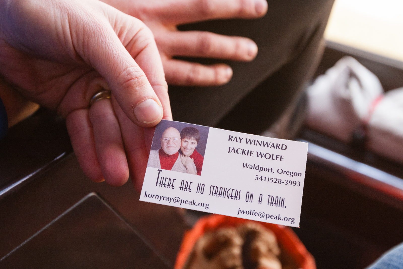
Mr. Kinsinger, the Amish butcher, had remarked in astonishment: “I met a man who said he spent 12 hours on an airplane, sitting right next to someone, and they never said a word to each other!” A former New York City cop-turned-massage-therapist from Oregon, who had ridden the Zephyr with her husband, carried cards printed with their contact information, and the headline: “There Are No Strangers on a Train.”
Abraham Lincoln’s idealism about the first transcontinental railroad’s forging national unity may have been bound up in political pragmatism and economic ambition, but a core sentiment remains true: as a train crosses borders, the boundaries between its riders dissolve. Those crosshatched lines on the map stitching the country together are also a metaphor. I witnessed community and saw everybody cherishing it.
At least for now, train travel remains in what the former flight attendant I met called an “age of innocence,” by which she meant that you can keep your shoes on to board. It is a relapse into a simpler time.
With some cash, Amtrak could add modern amenities like Wi-Fi and still preserve that slower pace that makes train travel a salve for our modern psyche, the perpetual motion lulling the rider to stillness, like a rocking cradle, and that hushing sound: choo-k-choo-k-choo-k-choo-k-choo-k.

The Robotic Search For Lost World War II Airmen
POPULAR SCIENCE | World War II combat pilots have been lost at the bottom of the Pacific Ocean for nearly 70 years. Now autonomous robots have been deployed to find them.
FIRST PUBLISHED IN POPULAR SCIENCE, SEPTEMBER 2013
ON A BRIGHT MORNING in mid-March, Pat Scannon stands on the deck of a 40-foot catamaran looking for an airplane hidden in the waters of Palau's western lagoon. A limestone ridge thick with vegetation juts into the cloudless blue sky behind him. His quick-dry clothing, coupled with a red bandanna knotted around his neck, befits Scannon's role as an amateur archaeologist. He has spent the past 20 years making annual wreck-hunting trips to Palau, about 500 miles from the Philippines, to find aircraft that had been shot down during one of World War II's fiercest battles—planes that may still be holding their pilots. His organization, BentProp Project, works to repatriate their remains to the U.S. To guide the search, Scannon ordinarily relies on interviews with Palauan elders, military records, and maps hand-drawn after the war. But on this trip, he has a new tool at his disposal.
Two technicians in a nearby Boston Whaler cradle a small, torpedo-shaped craft, then lower it into the water. Scannon watches as its nose tilts down and its rear propeller pushes it beneath the surface. Out of sight, the autonomous underwater vehicle (AUV), an oceanographic workhorse called a Remus, begins gliding through the lagoon in a pattern that resembles the long, linear passes of a mowed lawn. From roughly 10 feet above the seafloor, its side-scan sonar sends out acoustic waves that build a two-dimensional map. The strength of the reflected waves also helps distinguish metal from mud or coral.
For a group like BentProp, the use of advanced oceanographic instruments is a huge technological leap forward and one it couldn't afford on its own. The vehicles come from the University of California, San Diego's Scripps Institution of Oceanography and the University of Delaware, which received a grant from the U.S. Office of Naval Research. The funding enables oceanographers to test new technologies while helping BentProp locate World War II airmen—an effort they named Project Recover.
The lead scientist is Eric Terrill, director of the Scripps Coastal Observing Research and Development Center. Board shorts and sandals make the athletic oceanographer look more surfer than scientist—he even brought a board on the research vessel for what he calls "wave sampling." For the past few years, Terrill's team has used a Remus to study the ocean circulation around Palau.
"Historically, on unmanned underwater platforms, you might spend the better part of your experimental time just ensuring the sensors were functioning, tracking the vehicle navigation, and charging batteries," he says. "The systems now have matured to where we can run them hard, like outboard motors. The oceanographic community is engineering new sensors for them and having them do smarter things during their searches."
When Terrill and Scannon met through a mutual friend on the island, a collaboration seemed natural. BentProp could find planes in a tricky marine environment—with steep terrain, fast currents, and coral heads—while Scripps tested circulation models and advanced imaging systems. "If we're able to use those techniques on natural environments, there's nothing to say we can't apply it to the man-made objects on the seafloor," Terrill says.
Scripps and the University of Delaware shipped 60 packages of equipment to Palau, including underwater vehicles, cameras, various types of sonar, and, for aerial surveys, an autonomous hexacopter drone that had been rebuilt to survive sea spray and aquatic landings. The mangroves growing along the shore around Palau are so dense that aluminum wreckage from aircraft has been found sitting on top of the tree canopy about 30 feet up.
This year, Scannon has his eye on a major prize: a B-24 that he believes had been shot down in Palau's western reef. With the oceanographers' help, he hopes, BentProp could find it. "On land our major technology was a machete, and underwater it was scuba tanks," he says. "The ability to extend our mission is, like, I don't know how to describe it. It's like starting out walking, and suddenly you're in a supersonic jet."
By the 1920s, Palau had grown into a thriving Japanese port for goods and services en route across the Pacific. Recognizing the strategic location, Japan established an airfield there, and after World War II broke out, it began to shore up its defenses—building hundreds of bunkers and caves to defend the islands from an American attack. General MacArthur, who wanted to secure islands to the east as he prepared to invade the Philippines, ordered that attack in 1944. The U.S. began with a furious air campaign that was designed to knock out Japanese vessels clustered in Palau's western lagoon and adjacent harbors, and clear the way for an amphibious assault.
These people died defending usThat September, the U.S. Marines landed on the island of Peleliu. Although they ultimately won that battle, it came at a terrible cost: 10,000 Japanese and 1,700 Americans were killed in action—the highest casualty rate of World War II's Pacific Theater. And between the beginning of the air campaign and the end of the war, BentProp estimates, 200 U.S. aircraft were shot down inside Palau's barrier reef. Some 40 to 50 planes and 70 to 80 airmen have never been recovered. Scannon, a medical doctor and founder of a biotechnology company, first visited Palau in 1993 as a recreational scuba diver. He came with a group looking for a Japanese naval vessel that had been sunk by George H.W. Bush, who flew torpedo bombers during the war. After the group found it, Scannon hired a local guide to take him to other wreck sites, where he eventually discovered the wing of a B-24. When he researched Palau's history at home, he realized there must be many more planes in ruins around the islands. "Palauans knew of them but didn't know anything about them," he says. He was particularly gripped by the thought that many airmen couldn't have survived the impact. "These people died defending us," he says. "And they deserve to be honored and, if possible, brought home."
So began Scannon's quest. He returned to Palau for the next few years by himself, chasing leads. Then in 1996, he formed BentProp and recruited volunteers, roughly half of whom are retired and active-duty military members, to help him search. Combing the jungle and surrounding waters, they located debris from more than five dozen aircraft.
Last year, local spear fishermen diving on Palau's western barrier reef stumbled across one of the most impressive finds: an intact plane. They alerted the owner of a dive shop, who passed photos of the wreck along to BentProp. Scannon's team eventually identified the plane as an American Corsair. It had sustained some damage to its left forward wing root, but the wing flaps were down, and the canopy had been locked open, suggesting that the pilot had ditched. "It had been sitting there unknown for 65 years," Scannon says. "It gave us great hope that there were other intact airplanes out here that no one has seen."
BentProp calculates that eight American planes, including a B-24 bomber, remain hidden in Palau's western lagoon. The B-24, in particular, would be a tremendous discovery. It carried 10 to 11 men, including a pilot and co-pilot, gunners, bombers, a radioman, and a navigator. Of the four B-24s BentProp suspects were shot down near Palau, two were found after the war. BentProp located a third in 2004; the organization notified the Department of Defense's Joint POW/MIA Accounting Command, and the remains of the eight men onboard (three had parachuted out, only to be apprehended and executed) were repatriated to Arlington National Cemetery.
Mission photographs from World War II show the fourth, a Consolidated B-24 Liberator, on a path toward the western lagoon. Two of its crew had bailed out midair, landing in Malakal Harbor to the east, where the Japanese took them into custody; the rest presumably went down with the plane. "We have very, very good information about what heading they were on during the bombing mission, and we have very good information about what heading they took leaving," Scannon says, on the deck of the research vessel during this year's expedition. "So bringing the two of those together essentially brings you right here."
The oceanographic team's official command center in Palau is on the second floor of the Coral Reef Research Foundation, but their unofficial headquarters is an open-air bar called the Drop Off, originally built for the production crew of CBS's_ Survivor: Palau_. Several days into the expedition, they head there for dinner and order a round of local Red Rooster beers. As they wait for their food, Mark Moline, an oceanographer from the University of Delaware, opens a Toughbook laptop and scrolls through sonar images produced by the Remus.
Grainy and reddish, the sonar images look like transmissions from Mars. Some show deep scours; others, shadowy trenches. The team have given the features names like Homer Simpson, Crying Baby, and SpongeBob's Grave. After identifying promising targets in scans, they will have to investigate in person, diving to the various sites to determine if the features are purely biological, like coral heads, or actual wrecks.
Moline pauses on an image with an oblong shape. On closer inspection, it seems to have intact wings and a tail. "We got a plane!" Moline announces. Everyone springs up and huddles around the screen, snapping photos with their phones. Their excitement attracts the attention of a Japanese man dining at the other end of the long communal table, who cranes his neck for a peek at the computer. Moline abruptly shuts the laptop; World War II wrecks attract dive tourists and salvagers.
The next morning, at the coral-reef lab, Terrill debriefs Scannon and the BentProp group. Paul Reuter, a Scripps programmer, projects Google Earth onto a wall. Reuter had used an archival map of observed plane crashes to mark Google Earth layers with known wreck sites; he then added a layer with intriguing objects that had turned up in the sonar images.
Terrill uses a laser pointer to indicate the newest find. "The hard edges provide bright scatter," he says. "There's a long shadow here and here." He then shifts his pointer to a spherical object about 45 meters away and wonders if it could be the pontoon of a floatplane.
"If that's intact, it tells me it was a low-speed impact, perhaps ditching," says Daniel O'Brien, a former skydiver and Hollywood stuntman who now volunteers for BentProp. "My first impression is that's a Zero"—a long-range fighter aircraft. "There are rounded edges at the tail. But if it is a floatplane, the only U.S. airplane it could be would be amphibious. The shape looks like a Kingfisher." Flip Colmer, a former Navy pilot who now flies for Delta, also with BentProp, reaches for the book Floatplanes in Action and begins flipping through color pictures.
The Kingfisher, O'Brien explains, was typically flown for observation and to rescue downed pilots. "If they were in this deep, it would have been on a risky endeavor. There weren't anti-aircraft along the ridge. But existing ships that were still moored had anti-aircraft. So for him to come in and land here, it would have been to pick somebody up."
During World War II, floatplanes in Palau often flew rescue operations. As they scooped airmen from the water, another plane provided cover overhead. BentProp knew that two Kingfishers on reconnaissance missions had disappeared during the war, and the western lagoon seemed the most likely location for them to have ended up. The identification number painted on the plane's exterior would have degraded by now; to confirm the exact craft, divers would try to recover a stamped metal plate riveted to the inside of the cockpit. "It's our holy grail," O'Brien tells me.
Colmer cautions the group about jumping to conclusions. The Japanese also flew seaplanes. "If there's any primer left on the interior of the cockpit—which will last longer than straight paint—that's one way to take a peek at it," he says. U.S. airplanes used lime-green zinc chromate; the Japanese had a red primer. The team will have to get a close look.
Guided by GPS coordinates from the AUV, Pat Colin, director of the Coral Reef Research Foundation, pilots the vessel across the lagoon to the approximate location of the mystery plane. Then Terrill lowers a device called an Echoscope over the side. As we creep along the surface, an onboard computer displays 3-D images of the seafloor in real time.
While side-scan sonar provides a general impression of contours along the bottom, it doesn't directly measure the elevations of features. The Echoscope, or multibeam volume imaging sonar, does, enabling oceanographers to map topography accurately and in high enough resolution to distinguish man-made objects. Terrill describes it as "the oceanographic seafloor-mapping equivalent of ultrasound sonar used to look inside the human body." Using the two technologies in tandem helps to narrow wide-area searches and then pick out targets from clutter on the seafloor, so that human divers maximize their time at the correct site.
With the boat now directly over the plane, the dive teams begin to suit up. Terrill fills his scuba tank with nitrox to allow himself more time to explore the aircraft 100 feet below. Shannon Scott, an engineer from Scripps, descends with Terrill, Colmer, and O'Brien. He carries a handheld sonar that displays acoustic images on an LCD screen, allowing the divers to zero in on the floatplane even in five-foot visibility. About 20 minutes later, O'Brien surfaces. "Well, it's not a Kingfisher," he says.
After descending to the plane, O'Brien noticed that the windscreen on the cockpit was located behind the wing. In Kingfishers, it was situated in front. He'd also detected a subtle distinction in the shape of the fuselage near the tail.
I strap on a scuba tank and jump into the water with Scannon, who wants to see for himself. We follow a rope line, pinching our noses on the way down to equalize pressure, until we arrive at the fuselage. It lays on a bed of thick sediment that our fins kick up into dusty clouds. Long, gangly strands of black coral grow up and through the corroded metal. The front motor and propellers have broken away from the body of the plane, so that it now resembles a chewed-off cigar or the burnt end of a firecracker. Scannon waves me over to the cockpit and places my hand on the gun mount. It held a 7.7mm machine gun, Scannon later explains to me, developed by the Japanese navy.
The next day, BentProp compares the aircraft in the western lagoon with a hundred different vintage planes. Eventually, the team determines that the wreck has all the characteristics of a Kawanishi E15K1 Shiun, code-named Norm by the Allies. The high-speed reconnaissance floatplane had a single engine, contra-rotating propellers, and a center pontoon that could be jettisoned during an attack. It also had a flattened beaver tail around the vertical stabilizer, an aft cockpit machine gun, and no wing armaments. According to BentProp, the Japanese manufactured nine prototypes; six were brought to Palau for combat testing, and all were shot down by U.S. forces.
Though it isn't an American plane, Scannon is pleased with the discovery. "It's a very unusual aircraft, one of the rarest archaeological planes you will find," he says. "And there's a very high likelihood that the remains are still on it." BentProp alerts the Palauan government, which will notify the Japanese embassy.
Of more than 60 aircraft BentProp has identified in Palau—half of which are Japanese—the team has recovered just one metal plate stamped with a serial number: that of the American Corsair discovered by the spear fishermen. That plate revealed the Corsair's story.
On November 21, 1944, a young Marine captain named Carroll McCullah set off from the American airfield to finish off a Japanese vessel that had been bombed earlier. On the way back, he and his wingman strafed four Japanese ammunition dumps; an explosion at the last one sent shrapnel into the oil cooler of his plane. McCullah placed a distress call and made for the island's western reef. Then he tightened his seat belt, locked the canopy back, and turned off the plane's engine switch. Placing his left hand on the cockpit coaming, he braced for impact.
"There was no shock," McCullah later wrote in a mission report. He launched his life raft and swam across the reef, where a rescue aircraft swept down to pick him up. For the rest of his life, McCullah—who, after his rescue, went back to the base, had a brandy, and then flew another mission the next day—retold the story of that landing. "And many other ones," his son, Patrick, told me by phone from Florida, where McCullah lives (with dementia) at age 92. "His tales were tall, but they were true."
Today, McCullah's plane rests intact on the seabed, with its nose up against the edge of the reef, like a car driven up onto a curb and abandoned. But time has turned the craft into a relic: corrosion has gnawed at the metal, and the reef has crept into the propellers and the engine; a large, bulbous coral head has taken up occupancy in the cockpit. Originally painted blue, with a white star-and-bar symbol, the aircraft has been scoured to bare aluminum.
Scripps wants to use its technology to document this chapter of the Corsair's story too, before it ends altogether. "We're not only here to find and detect underwater objects, but to get a snapshot of the state of those objects that may be corroding or eroding away in time," Terrill says. "There's a whole new field in trying to baseline-capture all the detail we can about these historic artifacts. I'm calling it digital preservation."
Suzanne Finney, an American archaeologist working with Palau's Bureau of Arts and Culture, joins us for the 45-minute boat ride to the site of the Corsair. Marine archeology rarely gets to benefit from such advances, she says. "Most of the work I've done, you've got a tape measure and some string and a dive slate and a pencil, and you're taking photographs and measurements by hand. And that's what you do." With data from the robotic vehicles, Palau can add downed aircraft to an inventory of the country's rich underwater sites, something previously unattainable for an office that can barely afford to buy gas for a boat. "There are a lot of wrecks in water that's inaccessible to diving," she says, "so you need remote-sensing equipment." By the time the expedition ends, the AUV has scanned 18.9 square kilometers of the seafloor at slightly better than 10cm resolution, an area that would have taken scuba divers a decade to explore. The sonar also revealed what Terrill says could be a new species of coral.
When we reach the Corsair, engineers lower the Remus, now equipped with GoPro HERO3 HD cameras, into the water, and it once again begins a methodical sweep. Back in California, Terrill and his team will use the thousands of captured images, plus hundreds of photos taken by human divers, to build a 3-D reconstruction of the plane. Terrill is beta-testing algorithms developed by Autodesk for the company's new cloud-based, reality-capture software, called ReCap; the software has been designed to model aboveground areas like historic sites and factory floors, and Terrill is evaluating how well it works in an aquatic environment, where light is distorted. "Man-made structures underwater are an ideal testbed for that," he says. "If it pans out, it'll be a great archaeological tool to baseline a lot of these wrecks."
Scientists and naval historians could use such technology to document how wreck sites decay. Oceanographers and biologists studying living structures such as coral reefs could also benefit from it; 3-D models would enable them to detect how ocean acidification and events like typhoons alter reefs over time. And, of course, Scannon hopes that one day AUVs will lead him to his biggest find, the final B-24, so that a perfect replica of it, too, can be recorded for posterity. For now, it still lies somewhere in the lagoons surrounding Palau, concealed by water and time.

Are You Following a Bot?
THE ATLANTIC | How to manipulate social movements by hacking Twitter.
FIRST PUBLISHED IN THE ATLANTIC, MAY 2011
ONE DAY LAST February, a Twitter user in California named Billy received a tweet from @JamesMTitus, identified in his profile as a “24 year old dude” from Christchurch, New Zealand, who had the avatar of a tabby cat. “If you could bring one character to life from your favorite book, who would it be?,” @JamesMTitus asked. Billy tweeted back, “Jesus,” to which @JamesMTitus replied: “honestly? no fracking way. ahahahhaa.” Their exchange continued, and Billy began following @JamesMTitus. It probably never occurred to him that the Kiwi dude with an apparent love of cats was, in fact, a robot.
JamesMTitus was manufactured by cyber-security specialists in New Zealand participating in a two-week social-engineering experiment organized by the Web Ecology Project. Based in Boston, the group had conducted demographic analyses of Chatroulette and studies of Twitter networks during the recent Middle East protests. It was now interested in a question of particular concern to social-media experts and marketers: Is it possible not only to infiltrate social networks, but also to influence them on a large scale?
The group invited three teams to program “social bots”—fake identities—that could mimic human conversation on Twitter, and then picked 500 real users on the social network, the core of whom shared a fondness for cats. The Kiwis armed JamesMTitus with a database of generic responses (“Oh, that’s very interesting, tell me more about that”) and designed it to systematically test parts of the network for what tweets generated the most responses, and then to talk to the most responsive people.
After the first week, the teams were allowed to tweak their bot’s code and to launch secondary identities designed to sabotage their competitors’ bots. One team unleashed @botcops, which alerted users, “You might want to be suspicious about JamesMTitus.” In one exchange, a British user confronted the alleged bot: “What do you say @JamesMTitus?” The robot replied obliquely, “Yeah, so true!” The Brit pressed: “Yeah so true! You mean I should be suspicious of you? Or that @botcops should be challenged?” JamesMTitus evaded detection with a vague tweet back—“Right on bro”—and acquired 109 followers over two weeks. Network graphs subsequently showed that the three teams’ bots had insinuated themselves into the center of the target network.
Can one person controlling an identity, or a group of identities, really shape social architecture? Actually, yes. The Web Ecology Project’s analysis of 2009’s post-election protests in Iran revealed that only a handful of people accounted for most of the Twitter activity there. The attempt to steer large social groups toward a particular behavior or cause has long been the province of lobbyists, whose “astroturfing” seeks to camouflage their campaigns as genuine grassroots efforts, and company employees who pose on Internet message boards as unbiased consumers to tout their products. But social bots introduce new scale: they run off a server at practically no cost, and can reach thousands of people. The details that people reveal about their lives, in freely searchable tweets and blogs, offer bots a trove of personal information to work with. “The data coming off social networks allows for more-targeted social ‘hacks’ than ever before,” says Tim Hwang, the director emeritus of the Web Ecology Project. And these hacks use “not just your interests, but your behavior.”
A week after Hwang’s experiment ended, Anonymous, a notorious hacker group, penetrated the e-mail accounts of the cyber-security firm HBGary Federal and revealed a solicitation of bids by the United States Air Force in June 2010 for “Persona Management Software”—a program that would enable the government to create multiple fake identities that trawl social-networking sites to collect data on real people and then use that data to gain credibility and to circulate propaganda.
“We hadn’t heard of anyone else doing this, but we assumed that it’s got to be happening in a big way,” says Hwang. His group has published the code for its experimental bots online, “to allow people to be aware of the problem and design countermeasures.”
The Web Ecology Project has started a spin-off group, called Pacific Social, to plan future experiments in social networking, like creating “connection-building” bots that bring together pro-democracy activists in a particular country, or ones that promote healthy habits. “There’s a lot of potential for a lot of evil here,” admits Hwang. “But there’s also a lot of potential for a lot of good.”

Theater of War
MONOCLE | To build up the Afghan National Army, the U.S. Marines create their own Taliban stronghold – in Nevada.
FIRST PUBLISHED IN MONOCLE, MAY 2008
NEVADA, HOME TO THE BUNNYRANCH, the Bellagio and the Burning Man festival, is an unlikely place for a radical Islamist to seek sanctuary, unless, of course, he wanted to wreak havoc in one of the US’s premier leisure destinations. But its arid mountain landscape closely mirrors Afghanistan’s, so when Marines camped in the state’s rugged Wassuk range learn that Taliban insurgents have hidden weapons in a nearby village (even if that village is populated by Afghan refugees hired from Dallas and San Diego to impersonate real villagers), it does not require a great suspension of disbelief.
Inside a tent in a snow-dusted valley, Major Daniel Geisenhof, 41, and troops from the iii Marine expeditionary force normally based in okinawa, Japan, sit across a table from role players acting as allies from the afghan National army (aNa).together they plan a morning raid on “Malakashay”, a mock village built nearby. over tea and dates, Geisenhof listens to the afghan commander’s plan. But Geisenhof has problems with it. there are not enough soldiers – it is unclear whether the commander is concerned about scaring the villagers with larger forces, or just doesn’t have more and is ashamed to admit it. It seems he also favors an aggressive raid, while Geisenhof believes a softer approach will avoid alienating the village. “I wouldn’t say this to the commander,” Geisenhof’s interpreter, an Afghan from Dallas, suggests. “It makes him sound weak.”
For Geisenhof, a chiseled Marine with combat experience in Iraq and Somalia, the moment calls for humilityand compromise. “This is a great plan, sir, but what if we’re ambushed?” He invites the commander to discuss more troops in private. A Marine supervisor nods approvingly. “One of the most important things you can do in these meetings is pimp the commander. Always let him save face, even if that means losing face yourself. His troops will see that, and they’ll both respect us more for it.”
“Everything with Afghans is a negotiation,” says another. “As Marines, that goes against everything we’ve known.” Yet this is the role – by turns mentor, ambassador and cultural neophyte – that Geisenhof and the 150 Marines training for three weeks last February outside Hawthorne, Nevada, will assume this year as advisers to the real ANA.

Major Daniel Geisenhof consults with ANA role players. Credit: Andy Isaacson
For these final pre-deployment exercises, called Mountain Viper, 25-man adviser teams maneuver Humvees and shoot AK-47s, bivouac in blizzard conditions, and learn the afghan dialect of Dari and cultural idiosyncrasies such as how Afghans skin goats (“they respect the hell out of the thing,” notes one Marine).
Some 180 refugees from American- Afghan communities are paid up to $250 a day to play villagers, insurgents and soldiers, and to toss out cultural insights. Many fled to the US to escape the Taliban, and say they participate in Mountain Viper to help their motherland alleviate its 25-year burden of war. “The Soviets made a lot of mistakes,” says a refugee now living in San Diego who is playing an ANA officer. “They didn’t know our culture or our people. What the Marines are doing is very smart. Hopefully, it will save lives in Afghanistan.”
Indeed, an upturn in violence there and a resurgence of Taliban control, which US National Intelligence director Mike McConnell estimates at 10 per cent of the country, have underscored the need for more capable afghan security forces. Last autumn, the US asked NATP countries for more forces to quell the volatile south. Meanwhile, 3,200 Marines were deployed to southern Afghanistan in March – 1,000 as ANA trainers – still below the 3,500 that General Dan K McNeill, commander of NATO’s International Security assistance force, has requested.
Mountain Viper is an answer to this shortfall. It is the most immersive environment the Marines have created to train its adviser teams for Afghanistan, who had previously only received ad-hoc training at regional bases. Last spring, the Marine Corps formed the adviser training group to supervise the first Mountain Viper; a third is planned for this summer.
From its infancy in 2002, the ANA hasbeen built into a force of 45,000. It is targeted to reach 70,000 by 2010. Despite efforts such as Mountain Viper to improve relationships with locals, Afghan president Hamid Karzai has chastised the US and NATO for inadvertent civilian casualties – resulting from aerial bombardments and botched house raids –that threaten the tenuous popular support for the Afghan government and international presence. “That has been a challenging part of everything we do,”says US Army Major General David Rodriguez, a commander in eastern Afghanistan. “But part of that is because of how the enemy fights and how they try to have civilians in there.”
On the morning of the raid on Malakashay, a convoy of ANA soldiers and Marines in armored Humvees heads from base camp toward the village.
Malakashay consists of a dozen small shelters with painted rock and mud façades amid the sagebrush. Chicken korma scents the air. When the pickups arrive, the Afghans jump out and descend on the houses. They seize an insurgent guarding a weapons cache and bring him to Geisenhof, who then engages in village diplomacy, or rather, damage control – shaking hands with elders, reassuring them. Later, in a tribal council with the ANA commander, villagers complain that ANA soldiers stole antique glass from a home during the raid. They ask if the Americans could donate a water pump, tractor parts, and help clear landmines.
“You have to be a creative story- teller,” a supervisor advised Marines earlier on. “If you say, ‘Inshallah, we’ll get to it’, they’ll know you can’t deliver. It’s OK to dance around it. They’ll understand that you care and will look into it.”
Geisenhof says he will contact the UN about clearing the mines, but avoids making promises about the parts. “I’ll check our supplies.” the convoy then leaves for base camp: ANA role players are there, busy grilling kebabs.

Geisenhoff meets village elders. Credit: Andy Isaacson

Me, with Marines.
Engineer Mate Rimac Revolutionizes Electric Cars
WSJ. | The young Croatian built the fastest electric car in the world. Now his innovative designs are being licensed by manufacturers building the next generation of supercars.
FIRST PUBLISHED IN WSJ. MAGAZINE, NOVEMBER 2013
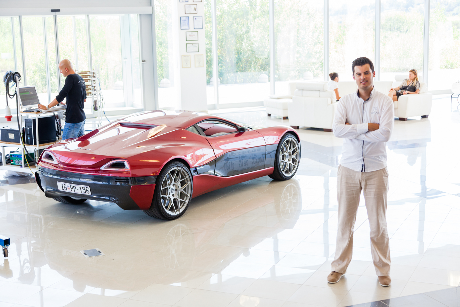
MATE RIMAC guides the Concept One—a prototype electric sports car he first designed when he was 21 years old—onto a stretch of road in Sveta Nedelja, a suburb west of Zagreb. The cherry-red vehicle is low, sleek and hardly subtle. Stepping gently on the accelerator, Rimac propels the car to 60 mph in less than three seconds. Jerking the steering wheel, he screeches through a roundabout before returning us to the parking lot outside Rimac Automobili—the Croatian engineer's automotive start-up—where he flings the car into a tight circle, pinning me hard against my seat.
"I'm not showing off," says Rimac through a haze of tire smoke. "I want to show you that the technology is reliable enough to do crazy stuff with an electric car. It's not just something that looks pretty at an auto show. We can build it today. We just need scale."
Unofficially, the Concept One is the world's fastest accelerating electric automobile. The car spreads 1,000 hp across four motors—one for each wheel. As the car turns a right corner, the front right wheel can break for a fraction of a second while the rear wheel generates power. It's an innovation that Rimac, now 25, points to as the "kind of stuff you can't do with an engine," and which defines the Concept One, in his self-confident estimation, as "the sports car of the 21st century."
The official Guinness records for the world's fastest accelerating electric automobile, which hang on the wall of the company's airy white-tiled showroom, belong to a converted 1984 E30 BMW parked in the adjacent shop. Rimac uses the boxy green vehicle as a "test mule" for technologies his company develops. He built that car when he was 19. At the time, Rimac had been winning international competitions for an electronic glove he devised in high school that functions as a keyboard and mouse, and came up with an idea for a car mirror system that eliminated blind spots.
After licensing his mirror invention to a European automotive supplier (Rimac is bound by an agreement not to disclose its name), by 2008 he'd earned enough money to buy the used BMW, which he then began entering into "drifting" competitions (a motor sport in which the car goes into a controlled skid). When the engine blew up after a few races, Rimac decided to marry his passion for cars and electronics. He'd always reveredNikola Tesla, the Croatian-born inventor and electrical engineer, and it occurred to Rimac that an electric motor—a source of instant power, free of cumbersome spark plugs and oil filters—would yield a superior sports car. "It wasn't about making the car environmentally friendly," he says. "The performance is just much better."
It took Rimac six months to convert the BMW into an electric car, using off-the-shelf components. Back at the Croatian racetrack, he was mocked. "What are you doing with this washing machine? Can I charge my phone with it?" competitors joked. Something always broke after each race, but Rimac kept tinkering, designing all the parts himself. The car eventually became "quick enough to whoop a Tesla in a street race," as one auto blog reported. By 2010, Rimac's DIY vehicle was trouncing even gasoline-powered cars.
"At that point, it started to get serious," Rimac tells me. A Croatian businessman approached him on behalf of Abu Dhabi's royal family. They wanted to see a prospectus. "They said, 'We want two cars,' " he recalls. "I was like, 'We're just a couple guys in a garage.' " He set to work on the Concept One.
What began as a hobby then turned, almost by accident, into a business. Today, Rimac Automobili employs 22 people, mostly Croatian engineers (the one non-Croatian employee, the company's head of sales, came from Tesla Motors). Thinking it would be wise to hire someone with actual car-making experience, Rimac Automobili initially brought in an engineer from BMW. But his high salary, and the specialization he'd grown accustomed to from working in the car industry, were not a great fit for the company's start-up culture, where the guy who makes the brakes also orders the parts for it.
"It was a learning curve—we made mistakes," Rimac admits. "But eventually I realized we were doing something right: developing cars for a lot less money than big car manufacturers and managing to beat them in many fields. We have an advantage starting with a blank sheet of paper. There's no heritage that we have to incorporate into the design."
For the first year, Rimac, then 22, hobbled along on a shoestring, helped by some seed money from his father—a shopping-center developer—and the promise of investment from Abu Dhabi. "I sold everything I had just to pay the rent," he recalls. In a superstitious mood, Rimac and his girlfriend, Monika Mikac, the company's head of public relations, concocted a reverse incentive: They vowed to swear off two of their biggest vices—chocolate and potato chips—for an entire year if the company finished a prototype for the Concept One by the 2011 Frankfurt Motor Show.
When the Concept One debuted in Germany, the industry took notice: The all-wheel-drive vehicle reaches a maximum speed of 190 mph and boasts an average range of 150 miles on a single charge. The power-to-weight ratio is on par with a Formula One engine. Rimac replaced conventional mirrors with cameras, linked by fiber-optic cables, and added a few other luxury flourishes, like self-closing doors.
Most of the components—almost everything but the battery cells and air bags—are developed in-house. Rather than use molds to make the wheels or pedals, as is typical in mass production, two large milling machines cut parts out of solid aluminum blocks, a costly process that enables the company to adapt quickly to design changes. "Only Formula One cars or spaceships are made this way," Rimac explains. "Nikola Tesla had to go to America to be successful. I wanted to stay here to give young Croatians a chance to work on something interesting."
With only one complete commercial vehicle sold to a European car manufacturer, the company was desperate for revenue. What sustains Rimac Automobili is designing and producing various components—electric power trains or battery management systems—for other automotive companies. Recently, Applus Idiada, an automotive engineering company in Spain, commissioned an electric supercar made with the windows and roof of the Concept One but built to different specifications. Rimac has sold batteries to a company that's building levitating trains, and he hints at a breakthrough in the works for "the next generation of braking systems.
"We can design and build prototypes fast and inexpensively, and not just for electric cars. We make chassis, electric parts, molds—all under one roof. But if BMW wants to develop a supercar with an electric power train, the best one on the market is from us," Rimac says. "Our technology could end up in a high-volume product under a different brand. If we had sufficient funding, we probably wouldn't do this kind of stuff. It's a simple matter of survival. Enzo Ferrari started to make road cars just to finance his race cars—he did it to pay the bills."
Building a show car to drive business to its engineering services is a strategy that many auto companies adopt, explains Christoph Stuermer, an industry analyst with IHS Automotive in Frankfurt. "Part of Tesla's business plan is to license out other technologies. There are similarities there," says Stuermer.
Looking ahead, Rimac intends to ramp up production of the Concept One, release a new model every two to three years and keep slashing the sticker price. (The car currently lists for $1 million.) He views his target customer as more of a Bugatti or Ferrari enthusiast, rather than a Tesla driver. Indeed, Rimac brushes off comparisons with Tesla, not just because he believes his company occupies a different market, but because Tesla's $465 million in federal loans places the company on an unequal playing field.
Although Rimac Automobili has carved out novel revenue streams, questions over its financing still dog the company. "The government won't help us, banks won't give us loans and there aren't foreign investors in this region," Rimac says. This hurdle is one shared by scores of other electric automobile upstarts operating out of garages and universities: Capital is scarce. Still, Rimac may be able to get by producing a handful of Concept Ones a year, appealing to that niche of customer that manages to keep high-performance automakers like the Italian supercar manufacturer Pagani afloat. For now, he can keep eating chocolate.

In a Changing Antarctica, Some Penguins Thrive as Others Suffer
NEW YORK TIMES | Global warming and the Adélie penguin.

Adélie penguins in Cape Royds, home to the southernmost colony of penguins. Credit: Andy Isaacson
FIRST PUBLISHED IN THE NEW YORK TIMES, MAY 9, 2011
ROSS ISLAND, ANTARCTICA— Cape Royds, home to the southernmost colony of penguins in the world, is a rocky promontory overlaid with dirty ice and the stench of pinkish guano. Beyond the croaking din of chicks pestering parents for regurgitated krill lies the Ross Sea, a southern extension of the Pacific Ocean that harbors more than one third of the world’s Adélie penguin population and a quarter of all emperor penguins, and which may be the last remaining intact marine ecosystem on Earth.
The penguin colony is one of the longest-studied in the world. Data on its resident Adélie penguins was first acquired during the 1907-9 expedition of Ernest Shackleton, the eminent British explorer, whose wooden hut stands preserved nearby. “This is penguin nirvana,” David Ainley, an ecologist with the consulting firm H. T. Harvey and Associates who has been studying Ross Sea penguins for 40 years, said on a morning in January. “This is where you want to be if you’re a pack ice penguin.”
Of the species that stand to be most affected by global warming, the most obvious are the ones that rely on ice to live. Adélie penguins are a bellwether of climate change, and at the northern fringe of Antarctica, in the Antarctic Peninsula, their colonies have collapsed as an intrusion of warmer seawater shortens the annual winter sea ice season.
In the past three decades, the Adélie population on the peninsula, northeast of the Ross Sea, has fallen by almost 90 percent. The peninsula’s only emperor colony is now extinct. The mean winter air temperature of the Western Antarctic Peninsula, one of the most rapidly warming areas on the planet, has risen 10.8 degrees Fahrenheit in the past half-century, delivering more snowfall that buries the rocks the Adélie penguins return to each spring to nest — and favoring penguins that can survive without ice and breed later, like gentoos, whose numbers have surged by 14,000 percent.
The warmer climate on the Antarctic Peninsula has also upended the food chain, killing off the phytoplankton that grow under ice floes and the krill, a staple of the penguin diet, that eat them, by as much as 80 percent, according to a new study published this month in The Proceedings of the National Academy of Sciences.
But in the Ross Sea a reverse trend is occurring: Winter sea ice cover is growing, and Adélie populations are actually thriving. The Cape Royds colony grew more than 10 percent every year, until 2001, when an iceberg roughly the size of Jamaica calved off the Ross Sea ice shelf and forced residents to move 70 kilometers north to find open water. (The iceberg broke up in 2006, and the colony of 1,400 breeding pairs is now recovering robustly.) Across Ross Island, the Adélie colony at Cape Crozier — one of the largest known, with an estimated 230,000 breeding pairs — has increased by about 20 percent.
Climate change has created a paradise for some pack ice penguin colonies and a purgatory for others, but the long-term fate of all Adélie and emperor penguins seems sealed, as relentless warming eventually pulls their rug of sea ice out from under them. Some scientists attribute the recent sea ice growth in the Ross Sea to the persistent ozone hole, a legacy of the human use of chlorofluorocarbons that cools the upper atmosphere over the continent, increasing the temperature difference with the lower atmosphere and equator, and over the last 30 years has delivered significantly brisker westerly winds in the summer and autumn. The warming of Earth’s middle latitudes is having a similar effect, increasing that temperature difference and sending stronger winds that push sea ice off the coast and expose pockets of open water, called polynyas, that give nesting Adélie penguins easier access to food.
Meanwhile, consumers’ appetite for Chilean sea bass (Antarctic and Patagonian toothfish) may also be benefiting Ross Sea penguins, as fishing fleets from southern nations converge on one of the last remaining refuges of the fish (Dissostichus mawsoni). A fishery in the Ross Sea that opened in 1996 and was certified sustainable in December by the Marine Stewardship Council, could ultimately serve Adélie penguins by reducing competition for Antarctic silverfish (Pleuragramma antarcticum), a sardine-size fish that the penguins and toothfish enjoy. Dr. Ainley and colleagues have reported seeing fewer killer whales in the southern Ross Sea since 2002. The whales feed on toothfish, and fewer sightings suggest that the fishery is already altering the ecosystem.
Researchers witnessed Ross Sea penguin colonies thrive during the 1970s when commercial whaling removed 20,000 Antarctic minke whales, also a food competitor of Adélies, from the penguins’ wintering area. Adélie populations eventually leveled off after 1986, after an international moratorium on whaling began (and remained static until the more recent influences of climate change). Japanese whaling of minkes resumed right after the moratorium was instituted, purportedly for science, a claim that conservation groups dispute and that has incited a confrontation in the Ross Sea between the Japanese fleet and the Sea Shepherd Conservation Society, an antiwhaling vigilante group.
“It has become difficult to separate whether the increase is due to climate change or fewer toothfish,” Dr. Ainley said. “Both factors seem to be working at the same time.”
On a chilly morning in January, the Cape Royds colony was clustered across the dark volcanic rock in crèches: month-old chicks, furry and pear-shaped with tummies full of krill, huddled near their parents as adolescent penguins, still too young to breed, acted “like teenagers trying to figure out the social scene,” in Dr. Ainley’s assessment. Their cuddly appearance is misleading, it turns out, a projection of human sentiment. “They’re really nasty to one another,” Dr. Ainley said, “and if you try to pick one up you’ll have your hands full.”
Climate models predict that the winds and sea ice will continue to increase in the Ross Sea for the next 30 to 40 years, at which time the region is expected to experience a tipping point, as rising temperatures and the waning effect of the ozone hole, now getting smaller, transform the climate into the kind now seen in the Antarctic Peninsula.
Already, that process is under way. The average summer temperature at McMurdo Station, the American research base on Ross Island, has inched up 2.7 degrees Fahrenheit in the past 30 years, records show, more than the global average. Scientists conducting longterm studies of lakes in the McMurdo Dry Valleys, Antarctica’s largest ice-free area, report that after a decade of cooling, some lakes in the Taylor Valley are now gaining heat. During this past research season the scientists recorded unprecedented lake levels caused by higher glacial runoff.
On Beaufort Island, north of Ross Island, glaciers have retreated over the rocky coastline farther than they have in 30,000 years, scientists estimate, a time before the last ice age. The receding ice has opened up more nesting habitat for the resident Adélie penguin colony, which has expanded to 55,000 breeding pairs from 40,000 in the last decade.
As the sea ice retreats, researchers expect that Adélie penguins living in the Ross Sea will be forced to shift their range farther south toward the pole. In a study between 2003 and 2005, Dr. Ainley and colleagues from PRBO Conservation Science, Stanford University, NASA and the British Antarctic Survey used geolocation sensor tags to track penguins from Cape Royds and Cape Crozier to better understand their migration patterns. Published last year in the journal Ecology, the study revealed how the penguins depart their nesting grounds in February, at the end of the austral summer, and head north on foot and ice floes to flee the protracted darkness of the Antarctic winter. They appear to stop on the sea ice about 300 miles from the boundary with open water, where they stay to forage and fatten before doubling back south to their island breeding sites ahead of the creeping northern night — an 8,000-mile journey.
By carbon-dating mummified penguin remains, researchers have been able to construct a long-term history of the Adélie in Antarctica, indicating that throughout the last ice age penguins changed their migration routes and colony locations in response to advances and retreats of the sea ice. However, their range appears to have never extended farther south of where it is currently, for the simple reason that Adélie penguins appear to need light — if only twilight — to forage and navigate, and as comfort against predators.
“Emperor and Adélie penguins have an obligatory association with sea ice,” Dr. Ainley said. “As the sea ice goes, these species will go.” The Ross Sea is projected to be the last place on Earth where sea ice will endure. But as the annual winter sea ice boundary retreats farther south, pack ice penguins may ultimately find themselves trapped behind a curtain of polar night for which they have no hardwired strategy.
Indeed, Dr. Ainley speculates, Adélie penguins face possible extinction not merely by a loss of habitat — but by an unshakable fear of darkness.

My Starring Roll in Laos
AFAR | While backpacking through a village in Laos, I invented a dessert sushi at a small restaurant. 7 years later, it had become a sensation.
FIRST PUBLISHED IN AFAR, MARCH/APRIL 2010
I ONCE INVENTED A DESSERT SUSHI, in Laos. It was made of bananas, peanut butter, sticky rice, sesame seeds, and honey. My then-girlfriend Lauren and I created it spontaneously one December afternoon in 2002, while dining on the deck of a restaurant in Muang Ngoi, a rural fishing village on the Nam Ou River in northern Laos. Scores of backpackers lay up in Muang Ngoi, so we called it the Falang Roll, using the Lao word for “foreigner.” The owners indulged us by providing the ingredients, and we promised them that the roll would be a sensation. They added it to their menu.
One evening, two years after that visit, I sat at my desk in California and wondered about the fate of the roll. Google pulled up a blog entry by a German backpacker about “an interesting dish called the ‘Falang Roll’ made by some falang who stayed for weeks in Muang Ngoi and taught them how to make this sort of dessert sushi.”
The roll lived! And it had even acquired an imprecise lore: We had stayed in Muang Ngoi for only three days. Over the years I sought updates from backpackers. In 2007, I posted to Thorn Tree, Lonely Planet’s online forum, asking if anyone had tried the roll. One reply: “YES I SAW THIS!… We thought it was hilarious but didn’t give it a try!” From another: “I actually have a picture of the sign!” The next year, I asked again. “Virtually every restaurant in Muang Ngoi has the Falang Roll,” said one. “Not sure how many people order, I certainly did not. Last thing I want is falang food in Laos.” And another: “Andy—you posted this same script last year. Yawn.”
I let it be.
In 2009, I found myself thumbing through a Lonely Planet guidebook on Laos at a friend’s house, and flipped to the “Eating” section for Muang Ngoi:
Nang Phone Keo Restaurant
(Meals, US $0.50–$1.50)
The ‘Falang Roll’ of peanut butter, sticky rice and veggies lures ravenous travelers to the open-air deck of this restaurant on the main street. Also whips up good foe.
I felt both honored by the Falang Roll’s immortalization and offended. Veggies? Evolution is natural, but this was metamorphosis. I felt like my legacy—let’s face it, at 32, the only one I could claim—was being hijacked.
I had to return to Laos.
Backpacker trail—a beaten path from Cuzco to Kathmandu filled with dog-eared Lonely Planet guides, Canadian flag patches, and discharged Israeli soldiers growing out their hair—is saturated with Western comfort foods. Banana pancakes are a guesthouse standard. Israelis have successfully transplanted shakshuka, a Middle Eastern egg-and-tomato breakfast, to backpacker haunts worldwide. And then there’s the phenomenal, spreadable, not-quite-chocolate Nutella, which now reaches far beyond the Eurail network.
The Falang Roll came from the same spirit of transplanted food: If Lauren and I created our own dish in Laos, could it catch on, even travel to Thailand or Malaysia or Goa? This was the thought that arose that afternoon from hammocks above the Nam Ou River. We had left careers in San Francisco, discovered a shared spirit for adventure, and set off for six months in Southeast Asia. The first month in Thailand we learned how to scuba dive and consumed street food with abandon. We crossed into Laos, trekked into hill tribe villages, and journeyed long days on bad roads with cheerful locals. We boated south down the Nam Ou to Muang Ngoi, eager to kick back for a few days and do laundry.
Rugged karst formations surrounding Muang Ngoi have kept the village isolated from roads, cars, motorbikes, and power lines—but not from Nutella. Some time after Laos opened up to foreigners in 1989, backpackers got word of Muang Ngoi’s relaxed pace and quiet, and the village’s single dirt road was transformed into a modest strip of guesthouses and restaurants.
Nang Phone Keo, the restaurant we went to, was run by a friendly couple with a cute 5-year-old son. The menu included peanut butter and honey sandwiches, French toast, waffles, and, of course, shakshuka. Lauren and I still argue about which one of us received the touch of inspiration for the Falang Roll after an afternoon meal there. Riffing on ingredients we knew the proprietors already had, we asked for a hunk of sticky rice, a banana, and peanut butter, which had to be ground fresh at the table with a wooden mortar and pestle. We used a water glass to flatten the rice, then spread a line of peanut butter and banana across it, and rolled the whole thing into the cylindrical shape of sushi.

The original Falang Roll, circa 2002. Credit: Andy Isaacson
The owners looked on, bemused, while we conducted our experiment. I asked to have a look around in the kitchen, where I found sesame seeds, which are used in Laos as a topping for dried river seaweed. We sprinkled seeds over the rice (in a nod to the Japanese original), cut the roll into bite-size pieces, and poured honey into a bowl to use as a dipping sauce. This one dish packed the nostalgia of an after-school snack, the density to stop the runs, and enough familiarity to sate culinary homesickness: a perfect backpacker food, we said. The price of 10,000 kip (less than $1) seemed about right—the same as shakshuka. Pleased with our creation, we left the village the next day.
When I arrive in Muang Ngoi in July to defend my legacy, the Nam Ou is swollen from monsoon rains. I disembark and walk up the new cement steps that ascend the embankment—on my last visit the steps were mud—to the main drag. Locals stand under doorways and ask, in their nonpushy way, if I’m looking for a guesthouse. I want to say, “No, I’m looking for the Falang Roll.” I walk the whole strip, to the end, surveying the left side of the road, where I remember Nang Phone Keo to be. There’s no trace of the place. I begin to worry that the Falang Roll might be extinct.
Deciding to wait until the rain lets up before panicking, I head toward my old guesthouse. That’s gone, too. I ask two younger backpackers from Canada and the U.K. if they can recommend somewhere to stay. The place they’re at is decent enough, they say, and cheap—$2 per night. But back near the boat landing is Ning Ning Guesthouse, which for $5 a night offers sturdy bamboo walls, glass windows, and a bar of soap. It occurs to me that despite shouldering the same blue backpack I had with me in 2002, I am no longer the frugal traveler I was then, because without much hesitation I spring for the Ning Ning.
The next morning I head back down the strip. A worker at Ning Ning has told me that Nang Phone Keo moved across the street, which is why I didn’t see it the day before. In the light of day, toward the end of the road I spot a familiar yellow sign hanging off a thatched roof. In red lettering, it reads:
ONLYPLACE BAGUETTE
AVAILABLE EVERY DAY!
WELCOME FOR YOUR BREAKFAST SANDWICH
BAGUETTE WITH PENUT BUTTER
WAFFLE – FALANG ROLLS
Nang Phone Keo still exists, and from the looks of it, so does the Falang Roll. I peer in but the only sign of life is someone sleeping on the floor in the back of the dining room. I head into a restaurant a few doors down, where I find a local guy named Hompan talking with a British traveler.
I show him two photos of Nang Phone Keo from my visit in 2002. (After all, I need some proof of creation.) One is of the Falang Roll, presented on a plate the moment after Lauren and I made it—six bite-size pieces garnished by a slice of unpeeled banana. The other picture is of the owners’ son, standing next to the menu board on which Lauren and I had written the name of the dish.

“I remember you!” Hompan says, after I show him the photos. “I worked at a restaurant next to that place, and I asked you to teach me how to make Falang Roll, and you said ‘OK, OK,’ but then the next day you go.”
“Oh, sorry, man!”
“Now many people here know Falang Roll,” he says, sweeping his hand across the village. “Seven years—long time.”
I ask him what has changed. There used to be only eight restaurants in town; now there are around 20, he says, though it seems that during this low tourist season local residents have converted many of them back to domestic use. There are certainly more signs for tourist services (“Oui Parle Francais,” “Haircut/To Shave the Beard/Shose Repairing”), including several for trekking and fishing guides. Hompan says there are more than 25 self-employed guides in town; in 2002, he had been the only one. Electricity still runs off generators, and only a few houses have telephone lines, but a cell tower is being installed over the village. There are two small temples; there used to be three. Opium is no longer sold in the weekly market. I ask about Joe, an American from Brooklyn who was visiting Muang Ngoi at the same time Lauren and I were here. It was his second visit. Villagers seemed to be fond of him—they knew his name, anyway. Of the thousands of falang who journey through Muang Ngoi never to return, he seemed to have developed a connection with this place and its people. Passing through superficially, I had been envious of Joe.
“Joe? Spiky hair and squinty eyes?” Hompan asks. “Yeah, I don’t know, he never come back.”
Hompan calls out to a woman who is walking past the restaurant. It’s Sopjian, the owner of Nang Phone Keo. I immediately recognize her warm face and smile. She doesn’t remember me, so I show her the photos. She looks at the pictures, then looks at me, and back again at the photos. We all laugh, thinking of the absurdity of the Falang Roll.
Hompan, Sopjian, and I walk to Nang Phone Keo, and I greet Khan, Sopjian’s husband, who is gentle and soft-spoken. Hompan calls him Buon Dien (Mr. Cool) because of his calm demeanor. Their son, San, walks in, now 12 but as sweet as the 5-year-old I remember. He’s wearing a pink-and-white-striped T-shirt, and the nails on his left hand are painted red. He looks at my photo of him from 2002 and laughs shyly.
I sit down at a table and, for the first time ever, order a Falang Roll.
I am relieved to see that Lonely Planet misreported. Khan delivers more or less an authentic Falang Roll. The peanut butter is now Skippy, and the higher cost of honey means it is used sparingly and only inside the roll. The Falang Roll is no longer a “dessert” sushi, but listed on a laminated, four-page menu under “breakfast,” along with waffles, pancakes, baguette sandwiches—and shakshuka, now more expensive than a Falang Roll. Elsewhere I notice “Fried Banana Flambée with lào-láo.” Lào-láo is the potent national rice whisky. Khan says the flambée was introduced by a French backpacker.
A Canadian couple sits down at the end of the table and looks over the menu. “What’s in a Falang Roll?” the woman asks Khan. I tell her she should try it and I explain that I invented it. She says that they had actually chosen this restaurant after reading about the Falang Roll in the Lonely Planet guide. “I also met a German guy in Thailand who said we had to try it if we ever reached Muang Ngoi,” she adds. Khan serves them a roll, and I observe them the way marketers scrutinize a focus group. They dip each piece in coffee, which they later explain is because the roll was a bit too dry. But otherwise, two thumbs up. My legacy feels secure.
I spend the afternoon getting to know the family I had never really met. I learn that 40 years ago, when Khan was a young boy, his family left for Luang Prabang to escape the bombs the United States was dropping on Muang Ngoi. Some villagers spent nearly a decade during the Vietnam War holed up in caves bored into the karst hills, Khan says, only venturing out at night to work their rice fields. In Luang Prabang, the U.S. Army paid Khan’s father to fight against the Pathet Lao, the homegrown Communist movement supported by North Vietnam. Most falang who visit Muang Ngoi—even those who swim in the caves, which are down a trail from the main strip—are unaware of this history. But the village is littered with remnants: Under Nang Phone Keo’s yellow sign lies a rusty, five-foot-tall bomb casing stamped with a U.S. seal. These days locals use the old casings as gateposts and planters.
One morning during my stay Sopjian invites me to her niece’s baby shower. I arrive with a case of Beerlao and join the men seated on the floor around bowls of sticky rice, spicy fishlaap, and soup. Cups of lào-láo are passed around with toasts for “good luck.” The midday buzz, the greasy hands and lips, a room full of people talking ever louder in a language I don’t understand, a stereo that pumps out a singer’s crooning backed up by a synthesizer: It’s a scene familiar to travelers in villages across the world. A local man who once spent four months in Atlanta tells the others in the room how quickly the fire department there responds to accidents, and how it’s not OK to drink on the job. More lào-láo, group dancing with twirling hands, and a woman who insistently bops her rear end into mine. I’m given a thumbs-up after being introduced as the guy who made the Falang Roll. “My wife can make it!” says Vita, who owns Vita’s Restaurant on the strip.
Visiting Muang Ngoi this second time, I begin to feel I’ve gone a little deeper than a transient falang. Being here during low season allows me to witness the village’s natural rhythm, which begins each day at dawn with the crowing of roosters and the beating of the temple drum. Boys and men set off on boats to fish. From tables along the main strip, women sell $1 bowls of noodles, lemongrass, and banana flowers to families heading off to work their rice fields. Kids carry babies and etch a local version of hopscotch into the dirt road. Dogs, chickens, and cats wander here and there. People sleep when the day is hot or rainy. They joke and gossip. Dusk arrives and the last boats return to shore. In the evenings, young and old gather around television sets to watch Thai movies. Sounds and fluorescent light spill out of open doorways onto the dark main road. Despite the year-round influx of falang who arrive with their clicking cameras, the social fabric seems in place.
I had come to Muang Ngoi thinking that with one culinary creation to my name, and maybe a bit of credibility, I might introduce another dish—perhaps another local variation of a perennial backpacker favorite. Pizza seems doable, so one day before I leave I take Khan, San, and Hompan into Nang Phone Keo’s kitchen, a tin-roofed annex behind the dining terrace, past chickens and a washing tub. Against the wall sit two open clay stoves with smoldering pieces of wood. I locate a pair of tomatoes on the floor of the vegetable pantry and hand them to San to blend with garlic, which he then cooks down in the wok to a thick marinara sauce. I work waffle flour, baking soda, and water into dough, and sauté some onion slices. Then I pound out a round, personal-size pie and lay it into the base of the wok, adding the sauce and onions and clumps of Laughing Cow cheese, a remnant of French colonialism. For the local touch I sprinkle on top pieces of kaipen (crispy Nam Ou seaweed seasoned with sesame seeds, sundried tomatoes, and garlic).
We wait 15 minutes for the dish to cook in the wok, then reconvene in the restaurant, crack a Beerlao, and share what is likely Muang Ngoi’s first pizza. Khan and Hompan chew in studious silence.
“So?” I ask. “What do we think?”
“Sep lai—delicious,” Hompan says, “but maybe more food on top like buffalo or chickenlaap.” I agree that the addition of Lao’s national dish, a marinated meat salad with fresh greens, herbs, and spices, would be an improvement. Khan voices concern about the long cooking time and impatient diners.
“Maybe some Israelis, they go away,” Khan says, waving his hand. A more pressing problem, though, is the village’s lack of a proper pizza oven. Hompan is hopeful. He is building a “jungle bar” on a plot off the main strip that he inherited from his family. There, he says, he will someday make our pizza.
I spend several more days in the village hanging out with Hompan, Khan, and San. By the time I leave Muang Ngoi it is with the understanding that sometimes travel is made rich not by what we take from the places we visit, but by what we leave behind. Even if that’s a dessert sushi or a Laughing Cow pizza, in Laos.
Hawaii’s Last Wayfinders
ISLANDS | Fewer than 20 people in the world can navigate the South Pacific using only glow sticks and instinct.
FIRST PUBLISHED IN ISLANDS, MAY 2011
ALENUIHAHA: THE CRUSHING SEAS. That’s what Hawaiians call this channel we’re crossing between the Big Island and Maui. The passage funnels prevailing northeastern breezes, turning them into ferocious winds. We’re sailing on instinct across this unpredictable water on a replica of a traditional Hawaiian voyaging canoe called Hokule’a. It’s the middle of the night. We have no radar on board. No GPS. Not even paper charts.
“They all have their own personalities,” Kalepa Baybayan says of the channels between Hawaii’s islands that for centuries have been the adversaries of the world’s best ocean sailors. “But this one has a mean streak in it.”
Kalepa, a navigator trained in Polynesian wayfinding, tapes two small glow sticks to the wood railing, illuminating a 90-degree angle. A makeshift protractor. This is our most tangible navigational aid for a night in the crushing seas.
Kalepa peers up to the celestial sky to locate a data point. He finds the northern constellation of Cassiopeia, and then follows the two end stars of its configuration to locate Hokupa’a, the North Star. Maui lies 30 miles northwest of the Big Island, Kalepa says, so we’ll need to sail on a 45-degree course from the North Star. Kalepa, who has a stout build and quietly assertive manner, sits unmoved at the back corner, eyeing the glow sticks to take a bearing.
“Steer down!” he calls out, meaning downwind, a feat requiring the full weight of three of us on the night shift leaning into the handle of a long wooden steering oar. My bare feet grip the wooden deck as the canoe pitches and rolls with jerky undulations, creaking in the darkness.
Half our crew of 16 — a mixed group of novice and veteran sailors, most of them Hawaiian — rest in cramped canvas sleeping nooks lining the deck. The night shift captain is a good-natured goateed character named Atwood Makanani (“Maka”), who mystifies me with long-winded raps on navigation and spirituality. Voyaging, Maka tells me, is “a world of magic, where the heavens come down to the earth and you actually get lifted and sail in the stars.”
“It’s like a dance,” he says. “Who’s leading and who’s following? As the canoe goes up a wave, it does a little hula, and you go with it. Elvis was never the king of rock and roll — we’ve been rockin’ and rollin’ since time immemorial.” So we’re dancing across one of Hawaii’s most notorious waterways, just as Maka’s Polynesian ancestors did. Without electronics. Reading the water’s moves. Looking skyward for help. Modern Hawaiians may have known that their Polynesian ancestors rolled across the Pacific, but until Hokule’a was built 35 years ago they had only the haziest idea of how it could have been done. Our three-day voyage from the Big Island to Oahu is a tribute to how this ancient knowledge narrowly escaped the dustbin of history. It will also prove to me the power of instinct. How it can be sharpened, even recaptured, to overcome the most distant odds.
“When I first saw Hokule’a,” Kalepa says, his voice rumbling through the sound of the wind, “it just grabbed my heart. It’s had an extraordinary power to affect people’s lives.” The canoe has made nine long-distance voyages, including to Easter Island, the Cook Islands and Japan, and has spawned a voyaging revival in other Pacific nations.
“The ocean doesn’t separate the islands,” Kalepa says of the vast sweep of Pacific. “It’s a bridge between our homes.”
The first Polynesians must have believed the same thing. They began sailing out of Taiwan 5,200 years ago, scholars estimate, reaching Fiji, Samoa and Tonga first before migrating east to the Marquesas Islands. By the end of the 13th century, they’d navigated to all corners of the 16 million-square-mile “Polynesian triangle” — Aotearoa (New Zealand), Rapa Nui (Easter Island) and the Hawaiian Islands. At a time when European sailors still feared falling off the edge of the Earth if they ventured across the sea — only discovering the Canary Islands off the African coast in 1336 — Pacific peoples had already reached islands unimagined.
The question later was, did they get there on purpose?
Their methods baffled Westerners for hundreds of years. When Capt. James Cook voyaged in the late 18th century, he was impressed by the speed of Polynesian double-hulled canoes. He brought aboard a Tahitian learned in astronomy and navigation who could plot a map of every major island within a 2,500-mile range from memory. The vessel we’re in now is not unlike the ones Cook admired. And neither is our captain so different from Cook’s ocean expert.
Kalepa tells me he was 17 when a Hawaiian sailor and an anthropologist began constructing Hokule’a to take the shape and weight of a traditional Polynesian boat, or va’a. The crew would test, once and for all, whether intentional two-way voyaging could have been possible. Their idea was to sail the 62-foot-long vessel from Hawaii to Tahiti and back without maps, sextants or compasses. But the Hawaiians had one problem: None of them knew how to navigate.
Then, Kalepa says, they found out about a Micronesian named Mau Pialug, one of six living navigators in the 1970s who knew the old Polynesian methods. As an infant Mau was placed into tide pools so he could learn to sense the ocean’s subtle rhythms. At age 7, his grandfather dragged him behind the canoe to overcome seasickness. He earned star trails across the Micronesian sky from maps carved into the sand. Mau agreed to teach a new generation of Hawaiian navigators, including Kalepa and Nainoa Thompson, his methods. In May of 1976 the group completed the 30-day voyage into Pape’ete. It was a watershed moment for Hawaiians. The old way was legitimized. Fused with modern astronomy, it became the new wayfinding.
Maka nods ahead toward the slopes of Haleakala. “We’re looking at the same shoreline and mountain that our ancestors saw for the first time on their canoe,” he says. “Imagine. You actually can feel that connection.”
The early morning sun reveals a Maui with no trace of ocean-view rooms or Technicolor swimming pools. Even when Wailea’s string of beach resorts comes into view, the creaking of Hokule’a evokes the sense of an earlier journey.
“The canoe is a metaphor for a way that allows us to walk through space and time,” says Maka, sailing off on another riff. “We build a simple canoe, as if it were a time machine. Have you seen The Matrix? Are you willing to go down the rabbit hole and click your heels twice?”
Fresh faces replace the bleary eyes of the night shift. Among the replacements is Tava Taupu, a 65-year-old master tiki carver and former lightweight boxing champion originally from the Marquesas Islands. He emerges from the sleeping quarters in a pink loincloth that exposes an impressive array of traditional tattoos along his arms and legs. A bleached-blond Hawaiian who goes by the name Snake assumes the captainship at the boat’s helm. Kalepa’s daughter, Kala, lays out a breakfast of sugary crumb muffins and sautéed jerky sandwiches, prepared over a propane gas stove inside a metal box. Before eating I do something I’ve been putting off since before dawn. I clip on a safety harness to visit the open-water bathroom. (Maka: “Drop the kids off at the pool without hitting the diving board.”)
Thankfully, the waters have calmed since we left the channel. Kalepa orders one of the crimson sails tied down. We drift slowly through the strait between Maui and Kaho’olawe, where Maka lives part time. Hawaii’s smallest island is dry and denuded, a consequence of its tortured history as a battleground for warring chiefs and as a penal colony, a pasture for cattle and goats, and during the 50 years after the Pearl Harbor attack, a target for everything the U.S. Navy had in its arsenal: aerial bombs, torpedoes and 500-ton dynamite charges. (The crater one left behind is now habitat for two endemic species of shrimp.) But many believe Kaho’olawe was also where early Hawaiian navigators were trained, for good reason. For voyagers it marked a reliable directional bearing south. The channel between the island and neighbor- ing Lana’i bears the name Kealaikahiki: “path to Tahiti.”
“We’ve sailed the route so many times it’s like an old trail for us now,” Kalepa says casually, adding that danger arises when you begin to doubt. I nod affirmatively. “You have to always assume that you know where you are, because there’s nothing on the ocean to get you back on track.”
Position is determined through dead reckoning, a running mental log of speed and direction. But we have no speedom- eter or digital compass. Kalepa shows me how they calculate speed: As we move along steadily, he counts out loud the time it takes bubbles to travel the length of the canoe.
“In good wind, we can sail up to 200 miles a day,” he says. ∏he sun is a critical compass point at dusk and dawn, but at night Kalepa relies on celestial navigation. He says the Hawaiian star compass divides the sky into 32 houses. At any given location on the planet, a certain star will always rise at the same location on the eastern horizon; it will also set at the same location on the western horizon.During this exchange Kalepa mentions that he carries in memory the rising and setting positions of over 200 stars. He extends his arm to show how, by using his hand as a sextant, he can determine latitude. Around Hawai’i, the North Star is situated 20 degrees above the horizon — the same as the latitude of the island. Under the clear sky Kalepa makes each calculation quickly, easily. But, I wonder, what if there’s fog? Or cloud cover? Kalepa demonstrates by closing his eyes slightly to better feel Hokule’a’s movements.
“You have to slow your body down to the rhythm of the ocean to detect subtle changes,” he says. Hawaiians call this instinct na’au. I can see that Kalepa has it. From the stories I’ve read, Mau, the mentor, did whatever it took to achieve it. But he also possessed an exceptional eye for reading cloud patterns to forecast weather and wind direction. He taught Kalepa that an approaching squall bearing brown or low clouds usually brings strong winds; black or high clouds foretell weak winds. An isolated stack of rain clouds on the horizon can indicate land. Foraging terns, seaweed or coconut shards are also telltale signs of nearing landfall.
“He never imagined his canoe moving across the sea,” Kalepa says about Mau. “He saw it holding a stationary posi- tion, the islands coming to meet him.”
The sun is setting over Lana’i as we sail leisurely up the west coast of Maui. There’s a calm vibe on deck as it becomes a floating patio, the crew reclining and chatting easily.
“The ocean brings uncluttered distractions,” Maka says to me. “Our sense of perception is heightened. Get on a canoe and look at what is still here — and try to remember.”
We reach Lahaina after dark. We’d been on the water for 20 straight hours, dancing to the ocean’s undulating rhythm. On dry land now, the discordant vibration of vehicle traffic while driving the island’s coast road feels as if the needle has been rudely lifted off a soothing record, our dance with the sea interrupted without warning.
The next day we sail across the channel from Maui to Moloka’i, and then on to Oahu. I watch Maka schooling a young first-time crewman from Molokai on how to coil a rope along the deck. A father-and-daughter team from Kauai are sharing duty on the steering oar.
“Wayfinding is more than navigation,” Kalepa tells me. The canoe embodies a set of values, including ‘ohana, family, and aloha, respect for others. It teaches discipline and sets direction. Or, as Kalepa puts it: “It’s a model for living life.”
As we sail past Lana’i lookout, a promontory on the eastern tip of Oahu, someone tells me a story about an exchange that Mau once had with Nainoa Thompson, during Nainoa’s training. As the two men stood on the rocky headland, Mau asked Nainoa: “Can you point to the direction of Tahiti?” Nainoa pointed south. Mau then asked: “Can you see the island?”
When I meet Nainoa later in Honolulu he recalls how that question had puzzled him. He contemplated it for a while, finally responding: “I cannot see the island, but I can see an image of the island in my mind.”
“Good,” Mau replied. “Don’t lose that image or you will be lost.” Mau might well have been making a statement about navigating existence in the world through dead reckoning. A people can only know who they are, or where they are heading, after discovering where they came from.

A Desert Film Festival Complete With Camels
NEW YORK TIMES | Of the honors reaped by the Steven Soderbergh epic “Che” — including a Golden Palm nomination and the best-actor award for Benicio Del Toroat last year’s Cannes Film Festival — the most surreal would have to be the white camel.
FIRST PUBLISHED IN THE NEW YORK TIMES, AUGUST 2, 2009
DAKHLA REFUGEE CAMP, Algeria--OF the honors reaped by the Steven Soderbergh epic “Che” — including a Golden Palm nomination and the best-actor award for Benicio Del Toro at last year’s Cannes Film Festival — the most surreal would have to be the white camel. That is the top award handed out by the Sahara International Film Festival, whose ceremony took place this spring in an isolated encampment baked dry by the desert sun, where the women were resplendent in colored gowns and the wearing of dark sunglasses was actually necessary.
Mr. Del Toro was planning to come, until retakes for his movie “The Wolf Man” called him to London. “He would have hallucinated,” said Alvaro Longoria, an executive producer of ‘Che,’ “ after literally dismounting the prize. (He gave back the animal before departing, receiving a camel statuette in its place.) “This is real. This is what Benicio and Steven tried to tell in the movie. It’s right here: a people fighting a war for their dignity and their land. The principles of Che Guevara are very important to them.”
The sixth annual Sahara International Film Festival claims to be the world’s only film festival held in a refugee camp, a conceit organized by filmmakers from Spain to bring attention to a political contest scarcely recognized beyond this corner of northwest Africa. Some 180,000 Saharawis, a Muslim people of Arab and Berber descent, live scattered in camps along Algeria’s border with Mauritania, exiles of a long struggle with Morocco over Western Sahara, a disputed slice of desert along the Atlantic coast abundant in fish and phosphates.
After 130 years of colonial rule, Spain abandoned Western Sahara in 1975 to Morocco and Mauritania. Morocco eventually annexed most of the territory and fought a 16-year war with the Polisario Front, a Saharawi independence movement backed by Algeria, which ended in 1991 with a cease-fire and the promise of a referendum that would allow the Saharawis a choice between independence and integration. The terms of this vote have been disputed and highly politicized ever since, while Morocco has maintained sovereignty claims over the territory, constructed a sand wall marginalizing Polisario forces to the desert hinterlands and been accused by international human rights organizations of abusing Saharawi dissidents.
“There’s definitely a historical responsibility,” said Dafne Fernández, one of a dozen Spanish actors and directors who attended the festival and who, along with her boyfriend, Carlos Bardem, and his brother Javier Bardem (who attended in 2008), has spearheaded a signature campaign to prod Spain into leading a solution to the impasse. Carlos Bardem, Pedro Almodóvar and Penélope Cruz are among the film personalities championing the Saharawi cause in Spain.
Over four days in May, Dakhla — a remote camp of 30,000 situated three hours from the Algerian town of Tindouf — became the stage for a show of solidarity and Saharawi culture. Polisario flags flapped where the logos of corporate sponsors might. Four hundred foreigners attended, most of them from Spain, and were put up in the mud-brick and tented homes of Saharawi families. Meals invariably included camel. In an amphitheater formed by sand dunes, the Spanish group Macaco joined local performers in a musical protest against what they called the sand “wall of shame.”
And each evening, after the mercury dropped from heights that limited daytime activity to drinking tea (temperatures often soar past 110 degrees), crowds of European bohemians and Saharawis assembled to watch a selection of international films projected onto a screen tacked to the side of a tractor-trailer.
Many of the films, coming from a number of countries, including Cuba and Algeria, were set in the context of struggle and oppression. Among those were “The Black Pimpernel,” a film by the Swiss director Ulf Hultberg about the 1973 military coup in Chile, and the German film “Die Welle” (“The Wave”), about the workings of totalitarian government. Screenings of foreign and Saharawi-made short films depicting refugee life evoked scenes from “Cinema Paradiso,” with enraptured audiences clapping to recognizable soundtracks and marveling at the larger-than-life portrayal of a familiar drama.

Each evening, crowds of European bohemians and Saharawis assembled to watch a selection of international films projected onto a screen tacked to the side of a tractor-trailer. Credit: Andy Isaacson
Throughout the festival, visiting instructors from film schools in Spain and San Antonio de los Baños, Cuba, taught audio-visual and storytelling workshops to young Saharawi women. With international funds, construction begins this summer on the Sahara School of Cinema, which will be located in another camp and offer a yearlong curriculum in film and television. Camps are acquiring video libraries with projectors and sound equipment.
Although these might appear to be odd luxuries for an impoverished, desert-dwelling people — the festival’s budget of 300,000 euros ($425,000) was picked up by a mix of public and private contributions — the Saharawis view filmed media as critical to their empowerment.
“The Saharawis need to express their ideas from their point of view, not just from the Europeans that come to see us,” said Omar Ahmed, the festival’s producer. “We need the tools to break out from under the information embargo that Morocco puts on us and project our culture and cause to the world.”
Meanwhile, as the United Nations this year renews attempts to broker a deal — and a growing impatience among younger Saharawi foments radicalism — the propaganda war continues. On the very same weekend, in the original Dakhla, a pleasant coastal city in Western Sahara under Moroccan control, the government there staged its own cultural festival to siphon attention from the camp. Or so the Polisario say: Morocco claims no such thing exists.

Lost (and Found) World
HEMISPHERES | Peru's Ocucaje Desert is known as the most abundant repository of marine fossils on the planet. It's also a preferred destination for legions of sticky-fingered scavengers. Meet the man who has vowed to fight the fossil thieves.
FIRST PUBLISHED IN HEMISPHERES, APRIL 2013
IT’S DUSK BY THE TIME WE REACH Marker 340 on the Pan-American Highway, where it connects with an unpaved road penetrating the Ocucaje Desert. My guide, Roberto Penny Cabrera, turns off the highway here. After several miles he stops the jeep, backs up 50 feet, drives off in another direction, stops again, then wheels the vehicle in disorderly circles over the sand. Satisfied that he’s thrown off anyone who might be trying to follow his tracks, Penny cuts the headlights and we continue on, in search of bones.
Paleontologists use a German word to describe lands like this barren stretch of Peru’s southern coast:lagerstätte, or “resting place.” A palimpsest of extinct and exotic marine animals—red-feathered mega-penguins, marine sloths, whales with legs—lies interred in a former seabed that rose when the Andes were squeezed out of the earth’s crust 140 million years ago. Encompassing more than 7,000 square miles, Peru’s southern desert contains what may be the richest trove of ocean fossils in the world, which has made it a target for rapacious collectors, unscrupulous scientists and legions of black marketeers.
Penny, who’s been exploring this desert for three decades, has an unusually detailed understanding of what’s out here (and, importantly, where it is), a knowledge that he believes brings great responsibility. “Whatever I have in my mind,” he says, “I will take to my grave.” Actually, this isn’t 100 percent true: As a professional guide, Penny makes a living taking people on fossil tours. But he insists he is selective about what he reveals, and to whom.
For this trip, Penny is taking me, along with his 16-year-old son and protégé, Nicky, to some of his more accessible discoveries. “Fossils? Oh, you’ll see thousands of fossils,” Penny says in accented English, steering us up a darkened ridge in the jeep he calls Deborah. Then he switches on the headlights, illuminating the countless chalky skeletal fragments that litter the desert floor around us. “Bones, bones, bones.”
We eventually reach a small plateau, and Penny swings the vehicle around with a flourish so that the headlights fall on a ghostly skull, over 6 feet long, half-buried and trailed by a string of vertebrae. “I’m not a scientist,” he says, killing the engine. “I’m not going to give it a name. I don’t care—it’s a whale, that’s all. But isn’t it beautiful to see, here, in the ground?”
The whale skull is an awesome sight. But in the silence and the glare of halogen lights, the spectacle also takes on a creepy feel, like that of an ancient crime scene. Penny lights a cigarette. “Come on,” he says. “Let’s set up camp.”
FOSSILS, PENNY TELLS ME, have a habit of going missing here. Part of the problem is that Peruvian conservation laws tend to be a little vague. It’s lawful to gather fossils for personal collections but not to remove them from the country, which means, in effect, that half the smuggling process can be carried out in broad daylight. After that, all you need to do is sneak them across the border. Nobody knows the rate at which the Ocucaje’s treasures are being ghosted out of Peru, but in 2010, agents at Lima’s Jorge Chávez International Airport seized almost 2,000 cultural items protected by law, most of them fossils.
In light of what Penny sees as officials’ indifference—to them, he says, “fossils are a business”—he has established himself as one of the most vocal critics of the government’s track record on protecting fossils. But he’s willing to go even further, sometimes taking matters into his own hands (he claims, for instance, to have collared a French paleontologist who’d been excavating without permission).
You get the sense that this cat-and-mouse game with fossil scavengers is something Penny rather enjoys—along with his image as a desert fox. When my bus arrived in the city of Ica the day before we set out, he approached wearing a safari shirt and fatigues, a long blade tucked into his belt and a cellphone strapped to his wrist. At 57, Penny is tan and sturdy, with blue eyes and a Burt Reynolds mustache. He shook my hand firmly and, seeing my surprise at his presence (I was supposed to call him from the station once I arrived), he explained that he’d had a hunch about what time my bus would get in, and even managed to guess the right gate. He took this as a good omen. “Look at these chicken bumps,” he said, holding up an arm.
Penny descends from Capitán Doctor Gerónimo Luis de Cabrera y Toledo, a Spanish conquistador who founded Ica in 1563. He lives alone, occupying a single room in a semi-decrepit yellow mansion built on Ica’s main square by his grandfather a century ago. His cluttered quarters resemble an archaeologist’s lair: satellite maps on the wall, dusty glass cases containing skulls and teeth, a desktop strewn with rocks. There’s also a teakettle, a mini fridge and a bedpan. On the balcony outside, he keeps a rope tied to the railing so he can make a quick escape in the event of an earthquake.
Penny doesn’t put much stock in domestic comfort—he is most at home outdoors, living simply and quietly. Our first night we dine on ramen, which Nicky prepares, and beans straight from the can. (Even in the city, Penny rarely goes anywhere without beans in his vest pocket and a spoon around his neck.) I drink water to stay hydrated; Penny has a Coke. Reclining in a lawn chair, he lights another cigarette, and—appropriately in these surroundings—starts to ponder life.
Penny explains that he used to own a mining company, earning a good living extracting minerals used in fertilizer. But in the late 1990s, a bridge he relied on to move his product washed out in a flood, wrecking his business and, ultimately, his marriage. He turned to booze. The desert had always held an appeal for him—his mother brought him here as a kid—but during this difficult period he found peace here, and eventually sobered up. The Ocucaje, he says, saved his life.
BY 9 O’CLOCK THE NEXT MORNING, the sun is already raging, giving the landscape the flat brightness of another planet. “You see the ground?” Penny says as we scour an area he knows to be rich in shark teeth. “You’re looking for a reflection. You need to see where wind has brushed. Then you look for plankton, and bones. When you find a bone, look closely. Maybe, just maybe, you find a tooth.”
As I strain my eyes in search of a glint, I try to imagine the scene that might have played out here tens of millions of years ago. Maybe a seal was frolicking in the surf one Miocene afternoon, oblivious to an approaching shark, and then—snap! In the ensuing feast, the shark loses a tooth, which drifts down and buries itself in the sediment. I spot something pointy partially covered by rock bits and broken shells, browned but perfectly intact, maybe 2 inches long. I hold it up. “Found one!”
“Good,” Penny says. “Find a few more of those little teeth, there’s a good chance you’ll find a megalodon.” He’s referring to Carcharodon megalodon, a prehistoric shark that measured 50 feet or more from snout to tail, with teeth up to 8 inches in length (though Penny claims to have uncovered a foot-long tooth once). “If I want to find a megalodon tooth, it takes me one day, two days. But I don’t give up.”
Moving deeper into the desert, Penny guides Deborah over steep dunes and into dun-colored valleys where the process of erosion has made neighbors of creatures that lived eons apart. At a burial ground dating back thousands of years, ossified human remains are strewn around the openings of looted graves. Scavengers have taken the valuable textiles, Penny says, and left the bones. “Who’s the guard here taking care of this!” he shouts, incensed, as a braid of human hair flutters in the breeze.
PENNY HAS A BIT OF A TENDENCY to romanticize the pre-Columbian natives of this desert. “They were wise people, and kind to each other,” he says that night by the campfire. His own family, he tells me, was torn apart by greed and materialism— and those traits are also driving today’s lucrative black market in fossils.
Given the clamor for these relics and the absence of hard-and-fast rules in Peru, it can be tricky to distinguish the good guys from the bad. Penny sees himself as the desert’s most ardent defender, but he isn’t above slipping a tooth into his pocket from time to time. His personal policy is to never dig for fossils, but once they are unearthed naturally, he figures, they’ll return to dust anyway—so it’s either him or the elements. He also makes clear that he never sells the stuff he finds.
One thing’s for sure, though: Penny’s stance on fossil scavenging has made him some enemies. On the final day of my visit, we drive by a whale skeleton that Penny often visits. A nearby rock face has been etched with writing that slanders Penny by name, calling him “thief” and much worse.
Penny appears rattled by these insults; he is particularly upset that Nicky had to see them. We spend the next few hours looking for shark teeth, but something feels off. Penny’s been to this area countless times, and he always comes across something. Today, after combing layer after layer of sedimentary rock, we find nothing. “Gypsum—it doesn’t belong here,” Penny says, pointing to a white powder on the ground. “[Poachers] put it around the fossils to help pull them up.”
The midday heat is unbearable, so I seek shade in Deborah’s passenger seat. But Penny insists on continuing the hunt: He’s noticed whirlwinds sucking up sand on a nearby slope, and wants to investigate. Once there he cries out, holding up a palm-size rock the color of oxidized copper. He pulls out a compass and holds it over the rock. The needle goes haywire. “A meteorite!” he exclaims, doing a celebratory shuffle.
A few minutes later, walking back to the jeep, Nicky points. “Look, Papa!” Lying in plain sight on the coarse gray sand is a 3-inch megalodon tooth. Then Penny spots something else. Not 10 feet from the tooth is a motorcycle track—the mark of the scavenger. Somebody was here before us, and missed the tooth.
“It’s perfect!” Penny cries. “It’s like Mother Earth said at the last moment, OK, guys, this one’s for you. You think it’s a coincidence? Guy should have found it—look at the motorcycle!” His eyes become intense. “This is what blows my mind about this desert world,” he says, throwing his hands to the sky. “Now, my son, compadre, you cannot take the smile off me all of the night!”

Credit: Andy Isaacson

Credit: Andy Isaacson

Penny and his son, Nicky, after spotting the Megaladon. Credit: Andy Isaacson

The Mysterious Buyer of Buford, Pop. 1
THE NEW YORKER | An anonymous Vietnamese businessman purchased the tiny town of Buford, Wyoming, population one. What did he want with it?

FIRST PUBLISHED IN NEWYORKER.COM, SEPTEMBER 3, 2013
Last year, an unusual Wyoming real-estate deal made international headlines: the tiny town of Buford, population one, had been purchased by an anonymous Vietnamese businessman. What did the buyer want with an exit off the interstate containing little more than a trading post and a pair of gas pumps? It was unclear; the businessman flew back to Vietnam without saying, and, until Tuesday, there had been little news from Buford.
The town, twenty-five miles west of Cheyenne, was founded in 1866 as a military fort. Its population once numbered two thousand, but in recent years has dwindled to just a single resident, Don Sammons—“a man with his own zip code,” he boasted on his Web site. Sammons positioned Buford as “the nation’s smallest town,” a claim advertised on three consecutive highway billboards. Yellowstone-bound tourists would pose for snapshots in front of the “POP. 1” marker, or purchase Buford mugs, key chains, and stick pins. “People had dogs named Buford, or an uncle named Buford—it always amazed me the connection people had to that name,” Sammons told me last week.
Sammons, a bearish sixty-three-year-old, moved to Buford from California in 1980 with his wife and son, and bought the ten-acre town twelve years later from the former owner’s widow, for a hundred and fifty-five thousand dollars. He relished the business challenge that came with inventing fresh ways to promote Buford, with its gas station, convenience store, modular home, restored nineteenth-century schoolhouse, garage, and tool shed. But after his wife died, in 2007, Sammons started looking for a way out. The sense of adventure had waned. “It was becoming a job,” he said. His grown son, who’d left for Colorado and who Sammons said is “more of an artist,” had no interest in carrying on the family business. So in April, 2012, Sammons put the entirety of Buford up for auction. “I brought Buford into the twenty-first century,” he told me. “I took it as far as I could.”
The sale was brokered by Williams & Williams, an Oklahoma auction house. Bidder No. 949 flew over from Saigon, and after an auction that lasted eleven minutes he walked away with Buford, for nine hundred thousand dollars. The deal included a post-office box, a liquor license, a plow, three vehicles, and a Union Wireless cellular tower. (Technically, it didn’t include an actual town, since Buford is not incorporated and therefore not considered an official municipality under Wyoming state statute, George Parks, the executive director of the Wyoming Association of Municipalities, told me.)
The unidentified Vietnamese buyer explained in a statement that he was a founder of a company that distributes home- and personal-care brands in Vietnam. “Owning this property can help us facilitate our distribution in the US, meaning we can bring to the US made-in-Vietnam products,” he wrote, adding, “It is an American dream!” Other than that, he said little about his plans.
The new owner was eventually revealed to be Nguyen Dinh Pham, thirty-eight. He told me last week that he didn’t actually have a plan for Buford when he bought it. “This town is very unique and famous,” he said. “I believed I could do something with it.” When he returned to Vietnam after the purchase, the town withered for a year. Sammons, who moved to Colorado after the sale, grew remorseful. “My assumption was that the buyer wanted what I did back in 1980—to be able to have a great lifestyle and slower pace of living,” he recalled. “But then I felt like all the work I put into the store for the last twenty years was in vain. It was very disheartening for me.”
He didn’t know that Nguyen was quietly laying plans to make Buford the face of a new Vietnamese coffee company. Last year, Vietnam surpassed Brazil to become the world’s largest coffee exporter, but there are few Vietnamese retail coffee brands, and none are sold in the United States. “We feel that’s unfair,” said Nguyen.
On Tuesday, he was back in Buford to inaugurate the town as the U.S. headquarters for the newly formed PhinDeli Corporation. (“Phin” is the metal filter used to brew Vietnamese coffee; “Deli” is short for “delicious.”) Nguyen will serve as the company’s chairman. PhinDeli’s C.E.O., Tuan Do, is a Vietnamese marketing executive.
Now, as drivers approach Exit 335 on I-80, they see billboards announcing the town’s rebranded name: PhinDeli Town Buford. (Officially, the town will remain Buford.) In one of the signs, a photo of Sammons has been replaced with an image of Nguyen, with his arms folded, wearing sunglasses. The other billboards show Nguyen and Sammons shaking hands and holding up a T-shirt, consummating the town’s handover.
Other than that, little has changed so far in Buford. Nguyen’s marketing plan is predicated on the town’s enduring charm. Tourists can still pose in front of the population marker, which will remain at one; after the town’s relaunch, Nguyen planned to return to Saigon, where he lives with his wife and two children, but a caretaker will occupy Sammons’s old house. Two employees will work at the store and gas pumps. The convenience store, in addition to selling PhinDeli Town Buford trinkets, will now sell bags of PhinDeli coffee. Visitors can try samples while seated at a new coffee counter; on the wall behind it, a ten-foot painted mural illustrates PhinDeli’s manufacturing process in Vietnam.
The company is releasing four coffee blends, which, starting Tuesday, will be sold through Amazon.com—and eventually, Nguyen hopes, in supermarkets. Visitors to PhinDeli’s Web site will find a “Vietnamese Coffee Statement” drafted in the form of a Declaration of Independence:
All men are created equal, that they are endowed by the creator with certain unalienable Rights, that among these are Life, the pursuit of Happiness and enjoyment of Coffee. We are the PhinDeli Corporation with a mission to bring the best of Vietnamese coffee style for all the consumers worldwide with its unique taste and 100% safety. We officially announce the Vietnamese Coffee Statement right in the U.S land Buford, owned by Vietnamese. We also officially announce the new naming of PhinDeli Town Buford with its 147 years of history.
PhinDeli: The Can-do Coffee
If you want to bring Vietnamese coffee to the U.S., Nguyen feels, what better place to start than a rural town in the American heartland? “Bill Gates started Microsoft in his garage, and now everyone uses Microsoft Office,” he said. “It’s not where you start but how you go.”
Sammons, meanwhile, hasn’t left Buford entirely: he has been named the town’s co-mayor and is advising PhinDeli on operating the convenience store and fuel pumps. “It’s a different direction than I would ever have taken it,” Sammons told me, of the town’s reinvention. “As a parent you do as much as you can do with a child, then you turn it loose to make their own choices and decisions. Buford now will be carrying on. It’s going to get bigger, and have a life of its own that I find thrilling.”